
Flight 19: The Point of No Return
I was interviewed about Flight 19 for a documentary recently and although I’ve limited the details of the experience to supporters of my personal Patreon (for travel writing and essays), there was one question in the pre-interview that I wanted to share more widely.
We were talking about the fact that radio stations triangulated their position but somehow no one managed to get that information to the squadron. The researcher was quiet for a moment and said, “So, if they had turned around at that point, would they have made it back to Fort Lauderdale?”
I’d never thought about that before and after a quick search on the internet, it didn’t seem like anyone else had either.
Now, the easy answer is that regardless, they would have been closer to the coast of Florida and thus much more likely to get rescued. But it seemed to me like there was enough information available about this flight that I might be able to work it out.
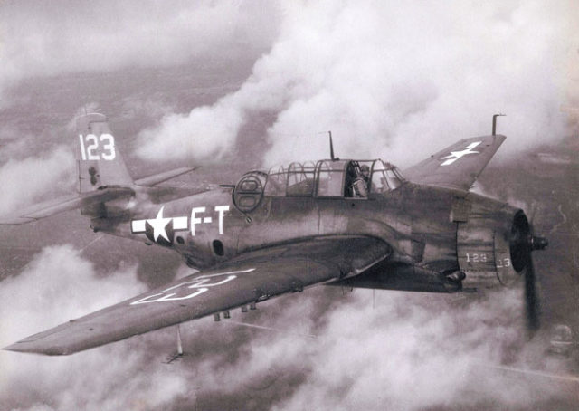
Flight 19 was a squadron of five TBM Avengers: a single engine aircraft manned by three crew (pilot, turret gunner and radioman/bombardier). The Avenger was designed by General Motors for strikes on ships, using aerial torpedoes. Enemy ships were able to avoid ship-to-ship torpedoes which only travelled at about 32 knots (59 km/h) underwater. In contrast, a torpedo launched from the Avenger could reach 260 knots (481 km/h).
On the 5th of December in 1945, Flight 19 was booked for a routine navigation exercise. Flight 19 consisted of five aircraft: FT-28, FT-36, FT-81, FT-3 and FT-117.
FT-28 was flown by the instructor and was an Avenger TBM-3D, the other four were all Avenger TBM-1Cs, the difference being that the 3D had increased fuel capacity and centimetric radar in the radar dome on the starboard wing leading edge.
Flight leader and training pilot Lieutenant Charles C. Taylor was leading the navigation exercise with four trainee pilots. He had just transferred from Miami and this was his first time flying this route.
For the rest of the crew, this was the third of a set of three navigational exercises, the last that the pilots needed before graduating. For the gunners and radiomen, it was advanced combat aircrew training. There were fourteen flight crew spread across the five bombers. The fifteenth crew member asked to be excused, as he already had the required number of hours, which meant that one of the aircraft was short a gunner.
The training flight was booked for 13:45 local time but Taylor was late that day, apparently having asked if he could be relieved of the training flight. There were no other instructors available to take his place, so he carried on to the briefing room to speak to the crew.
Taylor briefed the trainees with the weather, described as “favorable, sea state moderate to rough” with scattered clouds and a forecast of rain. Then he briefed them on the flight: a three-hour exercise known as “Navigation Problem No. 1”. This was a dead-reckoning exercise for a triangular flight plan.
A different pilot was to be the leader for each leg of the flight, with Lt Taylor flying at the rear so that he could grade the pilots on their performance. The first leg was to depart the Florida coast heading east to practise bombing runs over a shallow coral reef in the Florida Keys. Then, they were to continue on the same heading for 67 miles before turning north. On this heading, they would cross over Grand Bahama, the northernmost island of the Bahamas. From there, it was a direct flight south-west back towards Florida before crossing the coastline and heading south to return to Fort Lauderdale.
As far as I can see, the actual departure was between 14:00 and 14:10.
The navigational exercise, if flown correctly, was 583 kilometres. The first leg was 228 kilometres, the second 135 kilometres and the third leg 220 kilometres, after which they would need less than 20 kilometres to make it home. Let’s call it 17 kilometres to keep the maths easy; that’s a total of 600 kilometres for the flight.
The estimated time for the exercise was 3.5 hours, which means if they departed at 14:00-14:10, their arrival time back at Fort Lauderdale would have been 17:30-17:40. The Navy report estimates that they ran out of fuel between 19:00-19:30 which gives us something to work with in terms of endurance.
The weather was not great but certainly good enough for the exercises: surface winds 20 knots gusting to 31, sea moderate to rough, scattered rain showers, clouds as low as 2,500 feet. Outside of the showers, the conditions were considered to be average.
At 15:00, the captain of a fishing boat says that he was in that general area when he looked up and saw the aircraft overhead, heading east. This is the last confirmed sighting of the squadron. If they departed at 14:00 and we allow for an hour to fly 56 nm (103 km), then that fits in nicely.
By 15:40 they should have been in view of Great Sale Cay. At about this time, a senior flight instructor with call sign FT-74 was taking his students out on the same navigation exercise when he heard an unidentified transmission. An unidentified man was transmitting on the same frequency and asking someone named Powers what his compass read. He repeated the question a few times and then someone, presumably Powers, responded with “I don’t know where we are. We must have got lost after that last turn.”
The senior flight instructor tried again and this time, the voice identified himself as FT-28, the aircraft flown by Taylor, the instructor of Flight 19. The senior flight instructor asked what the trouble was.
At 16:11 Taylor explained: “Both my compasses are out and I’m trying to find Fort Lauderdale, Florida. I am over land but it’s broken. I am sure I’m in the Keys but I don’t know how far down and I don’t know how to get to Fort Lauderdale.”
It’s always seemed odd to me that it was considered that both compasses might have failed. Based on the weather and the direction of the navigational exercise, it seems likely to me that they had a 30-35 knot headwind or crosswind.
He was almost certainly not over the Keys. It was Taylor’s first time on this navigation exercise and he was used to flying out of Miami. He could easily have thought he recognised the area he knew well.
The senior flight instructor gave FT-28 instructions to fly to Fort Lauderdale from the Keys: . “Put the sun on your port wing if you are in the Keys and fly up the coast until you get to Miami. Fort Lauderdale is 20 miles further, your first port after Miami. The air station is directly on your left from the port. What’s your present altitude? I will fly south and meet you.”
It must have been embarrassing to have to ask for help, let alone have another aircraft lead him home. In any event, he is said to have sounded more confident when he responded. “I know where I am now. I’m at 2,300 feet. Don’t come after me.”
At 16:28, Taylor called again. “We have just passed over a small island. We have no other land in sight.” This meant that they couldn’t possibly be over the Keys as he would have hit the peninsula of Florida. Taylor must have realised this. “Can you have Miami or someone turn on their radar gear and pick us up? We don’t seem to be getting far. We were out on a navigation hop and on the second leg I thought they were going wrong, so I took over and was flying them back to the right position. But I’m sure, now, that neither one of my compasses is working.”
Air-Sea Rescue Task Unit Four at Fort Everglades heard the interaction; however, they did not have direction-finding gear. They contacted Fort Lauderdale for help but they couldn’t see FT-28 on radar although the IFF transmitter should have made the aircraft much more visible. They contacted Naval Air Station Miami to see if they had FT-28 on radar but they, too, could not see the aircraft. Word spread. Eventually, over twenty land facilities were contacted to attempt to pick up the lost flight on radar or with direction finders.
A different aircraft in the flight, FT-117, radioed saying, “We’re not sure where we are. We think we must be 225 miles east of base. It looks like we are entering white water.”
Another voice said “We’re completely lost.”
The senior flight instructor, FT-74, was struggling to maintain contact. “Your transmissions are fading. Something is wrong. What is your altitude?” A weak transmission came back from FT-28. “I’m at 4,500 feet.” That was the last message that FT-74 picked up as a relay burned out in his radio. He heard only silence on all frequencies. Frustrated, he returned back to base.
As FT-28’s transmissions were fading, the senior flight instructor believed that he must have been heading away from him, so FT-28 was flying north while FT-74 was heading south. “I believe at the time of his first transmission, he was either over the Biminis or Bahamas. I was about 40 miles south of Fort Lauderdale and couldn’t hear him any longer.”
The flight officer denied the senior flight instructor’s request to go out and lead Flight 19 back to safety. He contacted Air Sea Rescue Task Unit 4 and told them to instruct Flight 19 to fly 270 degrees (west) and then, on the basis that there was a problem with the compasses, told him to fly towards the sun, which must have been low in the western sky by then.
But Taylor disagreed. At 16:45, he transmitted: “We are heading 030 degrees for 45 minutes, then we will fly north to make sure we are not over the Gulf of Mexico.”
At 17:03, he decided to change course to 090 degrees for ten minutes. Air Sea Rescue Task Unit 4 heard Taylor transmit to the other Avengers. “All planes in this flight join up in close formation. Let’s turn and fly east. We are going too far north instead of east.”
Clearly not everyone was convinced. The responses were frustrated.
“If we’d just fly west, we would get home.”
“Head west, dammit!”
At 17:16 he changed course again. “We’ll fly 270° west until landfall or running out of gas”. By now they must have been halfway through their fuel and it was starting to get dark: sunset in December in Fort Lauderdale is at 17:30, the same time as they would have been expected to be back from their navigation exercise. In addition, they are losing contact over radio.
FT-28: “I receive you very weak. How is weather over Lauderdale?”
Air Sea Rescue Task Unit 4: “Weather over Lauderdale clear. Over Key West CAVU. Over the Bahamas cloudy rather low ceiling, poor visibility.”
FT-28: “Can you hear me?”
At 17:50, several land-based radio stations triangulated FT-28’s position (HF/DF fix) as being north-north-east of Fort Lauderdale.
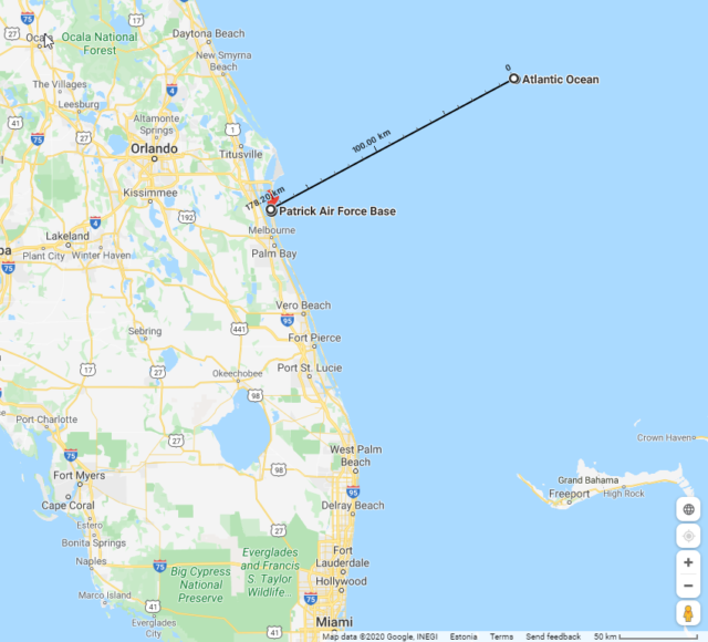
FT-28 was confirmed to be within a 100 nm (185 km) radius of 29°N, 79°W which I found on Google maps. Then I chose a spot 185 due east of that location, as a worst case scenario if they continued east throughout. I think we can agree that there was no chance of them making it back to Fort Lauderdale. However, there was another air force base in the area, Patrick Air Force Base. So drew a line back to Patrick AFB which came out to a distance of 350 km if they flew directly there.
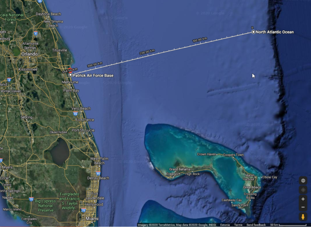
Now you’ll need to put up with my maths; I’m sure there’s a better way to figure this out but here’s what I came up with.
From 17:50 to 19:00 (the earliest point they might have run out of fuel) means that when they were triangulated, they had at least one hour and ten minutes of fuel left. They were expected to be able to fly 600 km in 3½ hours, which meant they could fly 300km in an hour and 45 minutes. No way could they manage 350 km in an hour and ten.
Now I concede that that is worst case scenario, especially as the squadron was flying west at the time when the location was triangulated.
At 18:04, Taylor was heard again on the radio. “Holding 270°, didn’t fly far enough east, we may as well just turn around and fly east again.” So if we presume that they flew west (270°) for 15 minutes, that would get them almost 50 km closer to the Florida coast and Patrick AFB was only 300km away. But with only an hour’s worth of fuel endurance, they still couldn’t make it.
However, if at 17:50 (when their location was estimated) they happened to be at 29°N,79°W precisely, then it was only 178 km to get to Patrick Air Force Base. That’s an hour and ten minutes, which means if they were going west and someone actually told them to keep going west, they would have made it on fumes. If just once on that day they were lucky and they were actually west of those coordinates, they would have made it to the coast with enough fuel to find Patrick Air Force Base and land safely.
But they didn’t. No one told the squadron that their location had been triangulated and that they were definitely north-north-east of Fort Lauderdale. As the darkness fell, they turned back and flew east again.
At 18:20 garbled messages were received from the squadron. “All planes close up tight . . . we’ll have to ditch unless landfall . . . when the first plane drops below 10 gallons, we all go down together.”
At 18:30, the Navy estimated that they had twenty minutes of fuel left. There were no further transmissions and the report concludes that they ran out of fuel somewhere over the ocean between 19:00 and 19:30.
There’s a lot I don’t know here, for example how likely is the full radius around the coordinates resulting from the triangulation. Still, I suppose the reason that no one has written about whether they would have made it back if they’d received that information is because it is such a close thing. It seems to me that it’s impossible to guess without knowing exactly they were.
Or can you think of a way to answer the question? Tell me in the comments.


There is a 500-page Navy report on the incident that seems to not be online yet; I found that someone has transcribed its findings, here: http://www.ibiblio.org/hyperwar/USN/rep/Flight19/index.html
“27. That at 1647R, 5 December 1945, the Gulf Sea Frontier and Eastern Sea Frontier HF/DF nets were alerted to obtain all possible bearings on transmissions from FT-28, who was transmitting on 4805 kilocycles.
28. That at approximately 1800R, 5 December 1945, an approximate HF/DF fix was obtained on FT-28 placing FT-28 within a one hundred mile radius of 29 degrees, 15 minutes north, 79 degrees, 00 minutes west, at 1750R.
29. That the 1750R HF/DF evaluated position was telephoned to the tower at U.S. Naval Air Station, Fort Lauderdale, at about 1810R, 5 December 1945.”
First, the position is 29°15′ North, not an even 29°, as is commonly quoted. They took over an hour to get this fix, and I would very much like to see the underlying data, as the 100 mile radius would put the flight inland at its western extreme. It should be possible to narrow it down better than that.
I think a thorough opinion on the position would depend on what we think their flight operations were, and which islands the leader mistook for which others, and how much off he thought his compass was when he set his subsequent courses.
The timing should probably based on the 17:50 fix being communicated to Lauderdale tower at 18:10, i.e. figure how far away from land they traveled in those 20 minutes, and then figure what wouldmhave happened if they had turned around then. If those 20 minutes were spent traveling East, then by 18:30 they’d be back to where they were triangulated to be at 17:50, with presumably less than an hour of flight time left.
A quick google on the speeds of the torpedo you quote, shows that the torpedo may be dropped at 260 knots from the aircraft, but will only do a maximum of 40 knots underwater.
Also since it can be dropped that much closer to a target ship this may increase the torpedo’s effectiveness.
AFAICT from maps and Wikipedia, the easternmost of the Florida Keys is more or less due south of Fort Lauderdale. (I would have guessed south by west, but there are some keys further east not accessible by road.) It’s even south of Miami (which could otherwise have confused someone who sounds like he didn’t have the local experience to monitor a navigational training flight.) Was there some other reef they were going to practice bombing at? Or were they confused about nomenclature from the start?
The coral reef is called “Hen and Chickens” and they were seen there by a ship at around 15:00, so the first half of the first leg of the flight seems to have been correct.
I don’t understand how the compasses can be broken. They’re chunks of magnets floating in a fluid. It doesn’t get more simple than that. How can 5 aircraft with 2 compasses each not be able to find at least a couple instruments that agree?
Or is this the “well it doesn’t say what I think it should say, therefore it’s broken” sort of broken?
Perhaps it’s the Bermuda Triangle sort of broken…
I have always wondered about the compasses too. And both of them at once? But then, there’s the Fort Lauderdale advice as to how to fly home if your compass isn’t working and the senior instruction also gave directions based on him not having a compass, so it sounds like it wasn’t a rare occurrence.
Previous commentators have summed up as much wisdom as can be said. How was it possible for a reasonably experienced pilot to get his actual position so very wrong that he obviously was even confused about the need to fly an easterly or westerly course? Yes, a compass can – and on occasion does – go wrong. Something as stupid as a screwdriver accidentally left by a mechanic too close to the instrument, a compensating magnet that somehow worked itself loose, something else that interfered like a chafed wire setting up an unwanted magnetic field, yes it can happen.
It did happen to me once on a banner-towing flight over Germany in very marginal weather. But we knew the area and even with limited forward visibility (about one mile) I was able to work out was was wrong. Of course, I was over land and had plenty of landmarks directly underneath. The mechanics did not believe me, thought that I had been disorientated until, on my insistence, they “swung” the compass and found an error of more than 30 degrees on some headings. But the crew of flight 19 were over water and all crew members, including the instructor, lacked the necessary local knowledge to accurately identify the land – islands – when they were able to see it. And with two compasses, if one is off, which one to trust? If the main compass is the culprit, the pilot may not realise his error until much later. By the time he checked the heading by interrogating the others he probably was already totally lost.
Much of my banner-towing flying was done in close formation. The formation leader was responsible for the navigation, as well as radio contact with ATC if applicable. The rest stuck on the the lead aicraft like barnacles to a ship’s bottom.
On one occasion I was sent with another pilot to fly over a factory where a sales rep was trying to convince the manager to use our aircraft for his advertising campaign. The lead aircraft was flown by the chief pilot, a superb leader who could be trusted in any condition, even if the weather forced the seagulls to travel on foot. He called me on the radio, told me to stick to him as he was going to give a bit of a show.
The sales rep who had, at the arranged time, brought the potential client to the window of his office swore later that we had rolled the Piper Super Cubs WITH banners in close formation. True? I do not know and Gerrit, the lead pilot, when I asked never told me. All I did was follow him closely during the manoeuvres, never took my eyes off him. Did the company sign a contract? I cannot remember either. All I really want to say is that, when flying in formation, if the leader gets lost they all do.
Thanks for this! I wrote the above before I read your comment and of course, I hadn’t really thought about items close to the compass, but that would surely mess it up. In fact, we had a problem like that on the Saratoga, where when the lights were on, the compass suddenly went 30° off course.
IMHO, Lieutenant Charles C. Taylor was not fit to fly, asked permission not to fly, but did so anyway as no one else was available.
A sad, but avoidable, loss of 14 men.
I agree, it seems likely that he was suffering from fatigue of some sort, based on his request and his subsequent back-and-forthing on the direction.
“In his 1980 book The Disappearance of Flight 19, probably the most authoritative and thorough book on the subject, author Larry Kusche […] looked into who Charles Taylor was. He was an experienced but not particularly talented pilot, only 28 years old, with a history of irresponsible blunders. During combat in the Pacific, Taylor had gotten lost twice before, and had to ditch planes both times. On this particular day, he didn’t showed up to the base until 25 minutes after they were supposed to take off, giving no explanation, and then asked if someone else could take his place. The request was denied. Kusche also determined that Taylor had not even brought a watch or basic navigational equipment such as a plotting board with him on Flight 19. Taylor was unprepared, unprofessional, and had a history of getting lost and ditching planes at sea.” ( https://skeptoid.com/episodes/4417 )
The wikipedia article speculates that Taylor’s belief that his compass was malfunctioning was a consequence of poor navigation and disorientation: “It is possible that Taylor overshot Castaway Cay and instead reached another land mass in southern Abaco Island. He then proceeded northwest as planned. He fully expected to find the Grand Bahama Island lying in front of him as expected. Instead, he eventually saw a land mass to his right side, the northern part of Abaco Island. Believing that this landmass to his right was the Grand Bahama Island and his compass was malfunctioning, he set a course to what he thought was southwest to head straight back to Fort Lauderdale. However, in reality this changed his course farther northwest, toward open ocean.” ( https://en.wikipedia.org/wiki/Flight_19 )
Peter Leffe found out that the radio logs show Taylor starting to refer to his flight as “MT-28”, which he takes as a sign of fatigue.
Seems to me that his superiors had a case to answer in allowing (forcing?) him to continue in a position of responsibility.
You could argue that Taylor was a scapegoat whereas others bearing some responsibility got off scot-free, a not unfamiliar event around that time eg USS Indianapolis!
Mendel’s contribution makes a lot of sense, in a way. It does not really make sense when taking into account Talyor’s (alleged) history of blunders. In any serious operation he would have been demoted and put back to be given additional training. He certainly would not have found himself in charge of a formation as an instructor with trainee crerws.
In that context, I agree with StevenD
A really minor point, the Avenger was designed by Grumman not GM. It was manufactured at both the Grumman plants (Navy designation TBF) and under license by General Motors (as the TBM).
This distributed type of manufature was common during WWII. For example, the B-24 Liberator bomber was designed and built by Consolidated with another 4,000 (+) being built, under license, by Ford.
Kevin, of course you are correct. The need for military equipment was so huge during WWII that often the demands far outstripped the capacity of the original manufacturers that designed them.
Not only aircraft, also tanks, trucks, guns would be produced by different factories, to the same design specifications.
E.g. the jeep. If my memory serves me it had been designed by Willys. They could not produce them fast enough, so more were produced by Kaiser-Fraser, I believe also by Chrysler. Maybe by others as well.
Kaiser-Frazer was founded on July 25, 1945, and obviously didn’t produce Jeeps during the war. However, in 1953 Kaiser bought the ailing Willys-Overland company for US$63,381,175 and merged the Kaiser and Willys operations under the name Kaiser-Willys Corporation.
Willys-Overland produced 370 000 Jeeps during the war, Ford produced another 270 000, for a Jeep completed every 2 minutes at the height of production.
Aviation fact: a variant of the Jeep was airdroppable and was airdropped on pallets for D-Day.
Thanks Mendel.
I was aware of some overlap, but not aware that the Willys-Overland takeover happened after 1945.
The point that I was trying to make was that the war required masses of products and in order to procure a sufficient number, also of cours to replace damaged or destroyed items, production was not necessarily confined to the designers’ facilities.
Admittedly I was not correct. I try to write all my comments straight from memory, I rarely if ever look things up. The aim is to make discussions more lively. Of course it can lead to inaccuracies.
Your main points stands uncontradicted, and you do make discussions more lively. It’s just the details that I remembered differently, and so I had to look that up, for my own peace of mind.
Just to appreciate what a great design that was, here are 8 mechanics assembling a Willys jeep in under 4 minutes: https://youtu.be/WtyDj7EsqSM Is there any airplane you can do that with?
Worth noting is that the us army air force did not change aircraft designations to reflect manufacturer. A b-17 was a b-17 whether produced by Boeing or lockheed-vega (although the block number identified the source–the enola gay was a b-29-45-mo meaning it was manufactured by martin in Omaha).
The use, in contrast, used different designations to identify different manufacturers even if the airframe was basically the same. The FM was a Grumman f4f wildcat manufactured by general motors,; the tbm was a tbf made by gm.
Yes, there were some indications, like block numbers identifying units built by one manufacturer or another. And they were produced very quickly indeed.
Although it must be mentioned that “4 minutes to assemble a jeep” was possible, but items like engines, gearboxes, axles, etc., came from another assembly line, ready to be installed. Even so, 4 minutes is a remarkably short time.
I once met a lady who had worked for Boeing during WWII. She was an artist, but her job was to make detailed sketches of areas where speed had led to a manufacturing error.That could be something like skin plates not quite fitting properly because holes for rivets had been drilled inaccurately. A lot of these mistakes were ignored; the average lifespan of a B17 was no more than perhaps 10 missions anyway – if that. And the cabins of these aircraft were not pressurised, so that eliminated the associated stresses.
But if the fault was such that the structural integrity of the aircraft was in doubt, she had to make an accurate sketch of the affected area or part. That would be sent to the design office where engineers would determine whether the aircraft could be released for service without rectification, or subject to a costly repair. Costly not so much expressed in money, but rather in the delay in completing the unit, but also if unlucky a blocking of the assembly line. Because these aircraft were really built in series production lines, and holding one up could have a knock-on effect on a whole line of aircraft.badly needed for the war effort.
Before we go to the next issue:
This was a very good topic. There was something in it for everybody, and I learned a few things.
Thanks to those who added to my knowledge. One is never too old !
As one myself, I believe Taylor may have been a Type 2 diabetic. That form of diabetes is otherwise known as adult onset diabetes. He may have been suffering from hypoglycaemia that afternoon. Hypoglycaemia can, if severe enough, cause mental confusion and disorientation. It would certainly explain why he asked to be excused from the flight but wouldn’t come clean with a reason; it would have been grounds for an indefinite suspension of his flying privileges, and perhaps ultimately the loss of his pilot’s license.
I have been following this sad story for years.
He must not have been feeling well and this contributed To situation. He just transferred. Sadly he thought he was in the Gulf of Mexico.
He was too stubborn to follow the advice of some of the other pilots who seemed to know where they were.
I have a theory that it was pilot murder/suicide by Taylor.
I would like to know if he was friends with Michael Berlito, the young man who apparently parachuted out of a plane that Capt. Edward Powers was flying. He was never found. This incident occured less than two months before Powers’ own disappearance.
Could Taylor have been close to Berlito and devastated over his death and (wrongly) blamed Powers and did this for revenge? Or just out of pure sadness?
Even if Berlito wasn’t a factor, I think Taylor was depressed about something and faked the lost scenario. I don’t see how he could have thought he was over the Keys or Gulf of Mexico. And he didn’t want the pilot who offered to come look for them, to come, saying he now knew where he was when the man said that.
Something seemed deliberate in this.
And I think Powers might have figured it out (too late) which was why he was ignoring some of Taylor’s communications in the end.
If Taylor was feeling suicidal, perhaps this was why he asked not to go out. Part of him wanted to so it but part was hesitant.
Finally, someone else who ascribes to my own theory…and isn’t afraid to give it a voice!
Several other suspicious happenings that day lend support to the idea that this loss was deliberate. One, Taylor was said to have received a letter, or telegram, earlier that day, the contents of which apparently shook him deeply. He spoke to no one about it, but pocketed said letter and took it with him on the flight.
Secondly, he refused to turn on his IFF gear as well as his ZBX homing equipment, both of which he was repeatedly asked to turn on, and both of which would have significantly aided rescue crews in finding the flight.
Something about this just doesn’t add up – that is, unless Taylor didn’t want the flight to be rescued.
It is frustrating to read the transcripts. Some of them knew where they were, but discipline kept them following him. They apparently found Gorda Cay (now Castaway Cay) and turned northwest, but missed Great Sale Cay (the one that looks like a kangaroo to me). How they could have missed Grand Bahama is a mystery to me, it is 100 miles long and runs east-west, and can’t be mistaken for anything else.
They should have crossed Grand Bahama near Pelican Point, but if they were a bit east of that, over the Sweetings Cay area, the broken islands do strongly resemble an area just east of Key West (Big Pine Key(?)). They could easily be distinguished because the Keys have the Overseas Highway and bridges connecting them. The Bahamas do not. Taylor seems to have trusted the seat of his pants more than his instruments, and tragically was about where he should have been when he convinced himself that he was lost!
I think they will be found eventually, because search technology is improving year by year.