
Part 2: The Analysis of Southern Airways flight 932
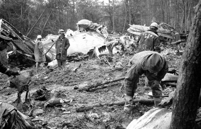
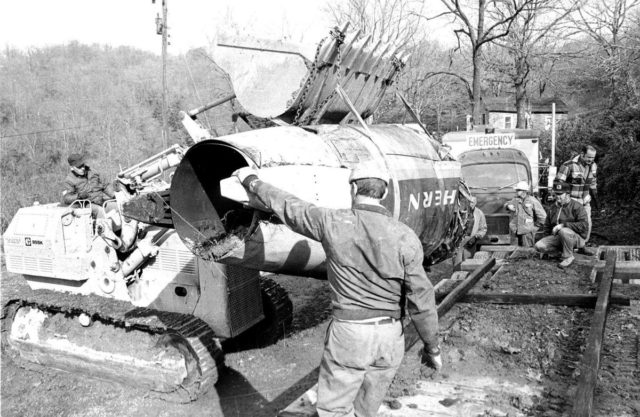
This is a continuation from my post last week on the crash of Southern Airways flight 932. In that post, I stepped through the sequence of events which led to the crash of the charter flight to Huntington Tri-State airport in a McDonnell Douglas DC-9 which killed all 75 on board.
The Chairman of the NTSB said of the accident: “If it hadn’t been for those trees, he probably would have made it. It was that close.”
The captain of that flight was 47 years old who had been hired by Southern in 1949. He held his ATPC with ratings in the DC-3, DC-4, DC-9 and M-202/404. He also held a flight instructor certificate with airplane and instrument ratings. He had 18,557 total flying hours, of which 2,1904 were on the DC-9. His first officer that day was less experienced. Hired in 1965, he held his commercial pilot certificate and had 5,872 hours, of which 1,196 were on the DC-9.
There were no known issues with the aircraft. Although the captain referred to issues at the performance of the autopilot, the descent was stable throughout and there was nothing to imply of a loss of control or a serious autopilot malfunction during the approach.
The airport lighting system, which consisted of high intensity approach lights, sequence flashers and high intensity runway lights, were all in operation and properly set at the time of the accident.
The report describes the conditions that night when the DC-9 was on approach as follows:
The terrain under the approach path was irregular with numerous hills of varying heights. There were few lights along the approach path excepting those of the refinery which were to the right of the inbound track. The lower clouds were ragged and the restrictions to visibility included darkness, rain, fog, and smoke. The pilot had his barometric altimeter, vertical speed indicator, airspeed indicator, and radio altimeter to aid him in establishing the desired descent profile. However, the pilot had little, if any, information instantly available to him regarding the elevation and character of the terrain below the aircraft or the flight path related thereto.
First Officer: A thousand feet above the ground, rate and speed good.
First Officer: Speed a little fast, looks good. Got bug and twelve.
Captain: See something?
First Officer: No, not yet. It’s beginning to lighten up a little bit on the ground here at ah… seven hundred feet.
First Officer: Bug and five.
First Officer: We’re two hundred above.
Charter Coordinator: Bet it’ll be a missed approach.
This comment by the charter coordinator could mean that he could see that the flight was approaching the Minimum Descent Altitude (MDA) and the runway was still not in sight. Other than that, though, the conversation doesn’t really help us to know what they were thinking or why they continued the approach past the MDA.
There’s clear issues with the cockpit resource management, as has been pointed out in the comments. There’s no clear checklist or challenge-and-response interaction between the captain and the first officer. The first officer didn’t call out five hundred, which was required, and never called out their rate of descent, even when the aircraft was descending faster than expected. The landing gear was lowered but no statement was made by either crew member in the cockpit.
When the first officer called out four hundred feet, they may well have been over the river valley, which was 500 feet above mean sea level. So if the 400 feet was from the radio altimeter, then they were only 900 feet above mean sea level, even though the minimum descent altitude for the approach was 1,240 feet above mean sea level. The runway was at 828 feet.
The swath cut through the trees, ground witness statements and the flight recorder altitude trace all show that the descent was stopped, power was added, and a gradual climb was commenced. Furthermore, the first officer called out airspeed in terms of a number (“Hundred and twenty-six”) instead of a reference speed, which is indicative of a go-around rather than a continuing approach.
This quote from the accident report is particularly interesting because later, the report concedes that it isn’t at all clear that the first officer was calling out an airspeed here. The board’s conclusion leaves open the question as to whether that final call of “hundred” meant the height above the ground or the current airspeed, as they were in the process of going around.
The captain responded to ask, “Is that the approach?” The minimum descent altitude of 1,240 feet would be 400 feet above the runway (what Rudy and I would call the MDH). So it’s reasonable to think that the captain presumed that they had reached the MDA for that approach. In that case it could simply be sloppiness that he hadn’t slowed his descent in preparation, so the DC-9 did not immediately level out.
However, I want to focus on the first officer’s monitoring of the approach. He made at least four call outs that are definitively height or altitude. If he was reporting the height above the ground, then there’s two ways that the first officer could have been making them:
1) He subtracted the airfield elevation (828 feet) from the altitude given on the barometric altimeter and called out the result, which would give them the correct height (over the runway, not over the terrain) to remain “400 feet above” until they had the runway in sight.
2) He erroneously used the radio altimeter, thus calling out the height over the current terrain rather than over the runway.
Here is a table from the report which shows:
- the call-out,
- the altitude as recorded by the FDR at the time of the callout
- the terrain elevation for the terrain that the aircraft was flying over at the time of the callout
- the height over the terrain, by subtracting the elevation from the altitude,
- and the height over the runway, by subtracting the runway elevation (828) from the flight recorder altitude.
| Call-out | Flight Recorder | Terrain Elevation (msl) | Height over Terrain | Height over Runway |
|---|---|---|---|---|
| 1,000 feet | 1,824 | 600 | 1,242 | 1,014 |
| ay, ah, 700 | 1,330 | 500 | 780 | 502 |
| 200 above (612 feet) |
1,224 | 530 | 694 | 396 |
| 400 feet | 1,005 | 690 | 315 | 177 |
As you can see, the first call certainly appears to be the height over the runway elevation. The second and third calls are closer to the height over the terrain, that is, those could have been done using the radio altimeter. And the fourth call, the important one, to show that they’d reached their MDA, doesn’t match up however we look at it.
Now, this isn’t an exact science. There’s a certain amount of variance here: the timestamps on the CVR and the FDR might not have been correctly aligned and even if they were, the exact location of the aircraft is affected by airspeed and wind, so the third column may not be quite correct. The first officer was clearly rounding so he may have called out shortly before or shortly after he believed that they had achieved those heights, adding another unknown factor.
It is certainly possible that all of the calls after the first one were made using the radio altimeter. Further, the last two calls, if they were indeed meant to reflect altitude, seem to be in line with the height above the ground. The hill with the trees reached a height of 990 feet above sea level, so about 150 feet higher than the runway that they were flying towards. Presuming that the terrain was rising again, they could have been 126 feet above the higher ground. The call of “hundred!” shortly before impact could either be the the height above the ground and the aircraft’s airspeed at that moment.
On the other hand, the investigators tracked the theoretical rates of descent between the calls. The calculated rates of descent do not match those recorded by the flight recorder, which tells us at the very least that some of these numbers must not be reliable.
The report’s main argument against this explanation is that a qualified pilot would not make this mistake, knowing they were flying over uneven terrain. Although the chart didn’t give detailed terrain information, Rudy shows in the comments of the previous post that it certainly made the high points clear. The investigators also struggled with the idea that the captain never glanced at the altitude information to notice that the call outs from his first officer were made from the radio altimeter.
It’s possible that he, like the first officer, was relying on his radio altimeter. A second possibility is that he was not using his barometric or radio altimeter, but rather was relying solely on the first officer for altitude information. Finally, he may have been including his barometric altimeter in his instrument scan, but was concerned with other items during the final stages of the approach to such an extent that he did not notice any variations.
That said, I have to admit, what with the outsider in the cockpit and his distraction with the autopilot, I don’t find it all that surprising that he didn’t notice.
However, there was another odd detail. When the barometric altimeters were recovered from the wreckage, both were correctly set at 29.67; however the first officer’s altimeter was out by 300 feet. Now if we look at the callouts in the table again, we can see that each is about 200 feet higher than the FDR reference to the actual altitude of the aircraft. If the altimeter was showing an altitude that was 200-300 feet high, then that would explain why the flight crew stopped their descent at about 300 feet below the MDA.
On the other hand, when the investigators dropped the barometric altimeter from a height, the indicated altitude increased by about 1,000 feet. So the altimeter could have gained those 300 feet in the impact. The report stated that they stopped testing the results of dropping the instrument because they didn’t want to break it; something that I’m sure would not stop the NTSB of today.
That’s an important point in itself. I mentioned that in 1970, cockpit resource management was nothing like as important an aspect of aviation as it is now. There’s also the point that neither the crew nor the charter coordinator thought it was a big deal that the approach plate was out of date. There was no sterile cockpit and the chatter from the back should have been cut off rather than half-heartedly ignored but again, clearly the coordinator was accustomed to being able to discuss fuel and other issues during the final approach. Sure, the captain didn’t handle the situation but based on the coordinator’s commentary, neither had any other captain.
That’s not the only thing that’s changed over the past fifty years. Reading the report, there are some unexpected omissions in how the NTSB handled the investigation.
The report mentions that Southern’s training program distinguished between the use of radio and barometric altimeters over level and irregular terrain but that Southern’s DC-9 Operating Manual “accentuated [the radio altimeters] use for all instrument approaches”. However, no one appears to have followed up on this, for example speaking to pilots at Southern to test their understanding of the radio altimeter’s weaknesses or interviews from the flight crew’s colleagues to discover if these actions during the descent were typical.
Similarly, the use of out-of-date charts, laughed off by the crew as normal, wasn’t followed up on in the recommendations, other than a vague statement that the FAA should keep a closer eye on airlines.
And finally, the issue with the barometric altimeter showing 300 feet out was left as a theoretical exercise, without the rigorous testing and simulations that the NTSB would have access to today.
Then there’s the following argument against the radio altimeter being incorrectly used during the approach:
The theory also assumes an unlikely dual human failure in that the captain was either also using his radio altimeter or did not recognize the differences between the barometric altimeter and the altitude information called by the first officer and was relying on the latter.
Now I’m not sure “dual human failure” is all that unlikely but more importantly, if there was an issue with the first officer’s barometric altimeter being 300 feet out, then we still have the same question: why didn’t the Captain notice? If that seemed unlikely in the first scenario, then why wasn’t it mentioned as equally an issue in the second?
Meanwhile, the investigators were not able to find any physical evidence of an issue with the static system or ports. And if there were a defect in the static system, this would also have given them inaccurate airspeed indications, which there was no reference to, unless there were an error in the pitot system which offset the error in the static system.
There is no known static system error which could cause a 200-foot altimeter error along with a corresponding air-speed error of -17.5 knots; without evidence of a phenomenon which could cause these errors, the Board cannot conclude that a static system error is supported by sufficient evidence to be termed a causal factor in this accident.
So both theories were dismissed as not having sufficient evidence to be termed a causal factor in this accident; a frustrating conclusion which could have been mitigated by more interviews and more tests. The probable cause was cited as the descent below Minimum Descent Altitude. I find this only slightly better than an explanation that the plane crash was caused by impact with the trees, to be honest.
However, we can certainly see steps towards modern aviation when looking at the conclusion and the recommendations.
Although the Safety Board has been unable to determine the probable reason for the unrecognized descent below MDA in this instance, the Board wishes to reiterate its concern with the general problem of landing and approach accidents and to re-emphasize its interest in the various preventive measures which might proof useful in reducing the rate of these kinds of accidents. There is a need for all segments of the aviation industry to continue to focus attention on the unique demands for crew coordination and vigilance during nonprecision approaches. Area navigation systems, now in the final proving stages of development, will apparently provide descent guidance capability within the aircraft and should be standard equipment on all future transport category aircraft.
(bolding mine)
Three recommendations were made:
- that the aviation industry continue to focus on the unique demands for crew coordination and vigilance during non-precision approaches, particularly with emphasis on developing area navigation systems with vertical guidance capability and heads-up display.
- That the FAA evaluate the need for the installation and use of ground proximity warning devices on air carrier aircraft
- That the FAA continue to emphasize the importance of Part 121.445 [US based airlines, regional air carriers, and cargo operators] carriers in its surveillance and inspection of flight operations under Part 121.
The NTSB had previously recommended the installation of altitude alerting devices (Ground Proximity Warning Systems) in reports released in 1968, 1969, 1971 and 1972 (the Southern flight 932 report was released in late 1972). However it was this high-profile crash which is largely credited for the focus on GPWS in the early 1970s and in 1974, the FAA required all large aircraft to install GPWS equipment.
In view of the apparent success of the nonstandard glide slope at Huntington, it is unfortunate that such an installation was not made sooner. However, the experience gained with this installation should provide a basis for possible application to other airports where standard installation criteria cannot be met without major construction.
If the DC-9 had been following this glide slope, then it would have been about 2,500 feet closer to the hill when it reached the minimum descent altitude. Only if it were pitched nose-down by 10° (an unusually steep angle) could it have crashed into the trees.
This student made a video about Southern Airways flight 932 as his “National History Day Project on Tragedy and Triumph” (which, to be honest, I watched with the sound off). I felt the images and newspaper headlines did a good job of showing the impact of the crash.


There is not much in part 2 to make me see this tragedy differently.1
Even in 1970, the radio altimeter was of NO USE in an approach, other than for some additional information. The determination of Cat one minima or decision altitude was NOT achieved with a rad. alt. The radio altimeter was used during Cat 2 or Cat 3 approaches. But there the relevant heights were calibrated and shown on the Cat 2 or Cat 3 approach plates.
Sylvia is correct: Some call-outs are not clear, it would have been more obvious in the context of the crew’s interaction. Some can have been related to altitudes or speeds. The CVR does not shed much light on what they were trying to tell each other.
What remains obvious: Human resource management and crew coordination were slack, even by the standards of 1970. The coordinator should have been told to remain quiet, his comments may have been a serious distraction.
The video made by the student is surprisingly professional and certainly heartbreaking.
Sylvia mentions the MDH, again:
MDH is Minimum Descent Height, determined with the barometric altimeter set at QFE and showing the HEIGHT above the airport.
MDA is Minimum Descent Altitude, determined with the barometric altimeter set at QNH and showing the ALTITUDE above sea level.
The former is easier to use as it will give the altitude as height, with the zero reference being the airport. The disadvantage is that it does not relate to the terrain.
The latter does relate to the terrain surrounding the airport. The disadvantage is that it relates to sea level. Therefore the minima have to be calculated by deducting the airport elevation from the MDA in order to obtain the height above the runway.
On a precision approach we use either DA or DH, same principle.
An airline uses either system, the crews are trained using either QNH of QFE. They do not change the altimeter setting halfway during an approach, nor are they at liberty to select either. QFE or QNH are part of the respective operator’s SOP’s.
During my flying years, many British operators preferred QFE. Use of this setting was mandatory in accordance with the companies’ procedures
This may still be the case, I don’t know.
How much would it cost to develop a system that uses directional radar (similar to Civilian Primary Surveillance Radar) that reports elevation relative to the runway, so the air traffic controller could includes that information as a safety check for pilots to verify their own readings/calculations? This could be built into the planes so that this info is automatically displayed, along with a warning if the approach is closer to the ground than it should be.
Mike,
What you refer to has been in use for a very long time, especially in the miltitary, in the form of PAR or Precision Approach Radar.
SAR or Surveillance Approach Radar has also been used, but did not show the aircraft height of course. Both systems were used to “talk-down” an aircraft. The disadvantage was that it required an approach controller talking constantly to only one aircraft at the time.
Nowadays GPS can be programmed to give precision guidance to aircraft nearly anywhere, the systems were already being developed before I retired 12 yearw ago. ATC at Dubllin Airport could give approach guidance to aircraft heading for Weston, a small strip to the west of Dublin. GPWS is mandatory and much more sophisticated, the transponder can give ATC an altitude check too.
The problem that aviation faces now is that the younger generation of pilots are becoming very reliant on electronics and without them their “situational awareness” suffers.
I know of one pilot who had been F/O on a modern airliner. His seniority earmarked him for promotion. When his command came up, he had to transfer to an older type, still without “glass cockpit”.
He just could not adapt to the basic flight director and navigation with VOR-DME and ADF, he failed and never made it to become a captain.
No I do not want to judge this colleague. This is just to illustrate that developing a certain skill set and methods that relate to certain stages of technology, the acquisition of the ability to work with modern tools or methods may come at the expense of the skills to work with older, classic tools or methods. Or vice versa. Ultimately the result, the outcome may be the same.
Jimmy Doolittle had far less at his disposal when he demonstrated the possibility of landing on instruments, but he did possess ample basic flying skills and the discipline to maintain his concentration.
All this is not really relevant to the Southern Airways 932 crash. The “glass cockpit” had not been introduced yet. But if the crew had prepared for this approach, concentrated and followed it, with proper adherence to the “step altitude” minima as clearly prescribed and shown in the approach plates, the accident would not have happened. The out of date plate was not relevant, except that it demonstrated a sloppy operation in general. The main difference was a changed holding pattern, they never even got that far.
I repeat again what was posted on the panel of the aircraft in the fleet of my beloved Tiger Club at Redhill, Surrey, of which I used to be an active member in the ‘seventies:
“All aircraft bite fools”.
Mike, the ADIRU in a modern aircraft knows exactly where the aircraft is, and the flight management computer has a database of all the runways. You don’t need a ground-based system these days to determine where the air raft is relative to the runway, it’s all on board.
Looking at the glide slope diagram, their descent angles make sense if they thought the airport was at 550 ft ASL. So we’re either looking at an altimeter malfunction, or a bunch of flatland pilots. The remarks of the captain regarding the autopilot and the downdrafts might then be the result of him not being aware that terrain height changes would affect the RadAlt; he’d think the aircraft had moved more vertically than his mental model of the aircraft position allowed for, when in fact the terrain height had changed. It’d be interesting to know which airports they were used to flying to, and how much experience they had with mountain operations.
Mendel,
You contribution makes sense, even if the investigation failed to determine whether or not the altimeter had been a factor. Wrong setting seems to have been ruled out. Malfuntion? Perhaps.
But one thing sticks out: Many people who react to this forum seem to be hammering on the Rad Alt. But this instrument, as I have been at pains to explain, had NO funtction in determining minimum sdescent heights (Not altitudes in this case, it refers to the distance between the aircraft and obstacles immediately below it!). The ONLY type of approach where it had anything more than a purely advisory function is in Cat 2 and Cat 3 ILS approaches.
Certainly a qualified and reasonably experienced crew of a DC-9 should know. Including this crew. So that aspect makes no sense to me.
“First Officer: A thousand feet above the ground, rate and speed good.”
Why does he call out the height above ground at all? Does that make sense to you?
“The report’s main argument against this explanation is that a qualified pilot would not make this mistake, knowing they were flying over uneven terrain.” That’s a failure of nerve, imagination, or knowledge by the report writer — nerve from worries about how the pilots’ union would attack any suggestion of pilot error (and the airlines would attack any suggestion their policies&procedures were weak), knowledge because even 50 years ago there was some understanding of how loosey-goosey (or downright strange) some pilots were, or imagination because mistakes are always possible — and much more possible when there are documented interferences (the coordinator butting in repeatedly) and failures of attention (the lack of such formal procedures as were standard even 50 years ago). More on knowledge: did the pilots actually know how random the terrain was? Some of what Sylvia said last week suggests they didn’t, or at least didn’t have details for that approach rather than a statement that the minimum safe flying altitude in the sector as a whole (500-1000 square miles?) was well above the airport altitude.
I find the emphasis on GPWS fascinating. How much does such a system look forward as well as down? Would the systems available any time in the 1970’s have given a timely warning given the irregular terrain and the airport’s high situation? I flew a few times into Worcester MA (KORH), which IIRC is even more above the immediate surroundings (over 500 feet above its name-city); how much warning of a low approach would GPWS give there?
But GPWS was in the future; ISTM that Rudy’s observations (which could be summarized as “terminal(!) carelessness”) describe the real problem here, and what the report should have concentrated on. Recommendation #1 starts to point at this, then veers off into planned electronic aids that would do nothing if the crew didn’t pay attention to them; in particular, it’s not clear that a heads-up display would have helped in those conditions. The recommendations are also at best very weak on a factor that Sylvia pointed to last week: the pilots were unfamiliar with the airport and their employer was not required to review the airport with them. (#3 might have been intended to saunter vaguely in that direction; possibly the writer was also steering clear of anything suggesting that the airline was at fault.)
The NTSB chair’s comment amplifies what someone (Mendel?) pointed to last week, but the report indicates that the airport finally got a vertical-axis ILS (albeit “nonstandard”) between the crash and the report date, so I guess the writer(s) figured recommending clearing some of the trees on the top of the adjacent peak wasn’t useful.
Chip,
Some points you make are plausible, but it seems that few readers understand:
– Jeppesen has been the main producer of route manuals, and for a very long time. They still are the golden standard. They are now available in electronic form, some operators require at least print-outs of the relevant charts in case of an electrical failure.
– Jeppesen is meticulous and extremely complete. Regulations, entry requirements, class 2 Notams, interpretation of TAFs, METARs, de-icing priocedures, emergency procedures, you name it: it can all be found in the “Jeppy”, combined with airway charts, area charts and the various and very detailed STARs, SIDs, airport charts and approach charts.
– There will have been far more information available to the crew than what is shown on the two specimens that Sylvia printed out: One that was out-of-date at the time of the accident, the other one the current one at the time.
– Even the old chart would have been sufficient, the only difference that I could see was a holding pattern on the SE side of the airport.
– If the airport is important enough, there will have been more information on area charts than just one or two pages.
– Jeppesen ALWAYS printed accurate terrain information: Apart from a minimum sector altitude which gives information on safe altitudes within a sector, either based on the airport reference or on the FAF (final approach fix) within a range of 25 NM.
– In addition, Jeppesen publishes “spot heights” indicated by a black dot and a height.
So unless the crew were rank amateurs, there was absolutely no excuse for them not to be aware of terrain or obstacles. They were not, the captain had a lot of experience dating back to post-war pioneering days.
Perhaps, if we were able to dig a bit further, this might be where the lack of adherence to cockpit crew procedures and poor crew management originated. The print-outs of the CVR conversations that we see here are highly suggestive of a very casual and laid-back cockpit crew coordination. I cannot see any evidence of a proper preparation for this approach; if they had, the capture of a false glideslope would not have been the course of confusion. This was probably a major factor in the accident.
We know that these guys are quite loose in the cockpit, taking shortcuts.
I’m imagining that they had figured out that they could fly a QFE approach (relative to runway height) with the RadAlt and it’d usually work out as the terrain was usually reasonably flat; they see the runway in time anyway. Except this time, it didn’t: very uneven terrain, poor visibility, and a mountain in their path.
CHip, an old-style GPWS wouldn’t have helped, as the aircraft was already configured for landing, with gear down and flaps 25. A modern TAWS has a terrain database and would’ve anticipated the impact, and also knows about glide paths.
Mendel,
I am still confused about the altimeter setting.
In the ‘seventees, insofar as I am aware, most airlines in Europe and the USA used QNH. QFE was more widely used by British operators.
If it is correct what you imply – use of a QFE setting by the crew of 932 – this would have been a deviation from what I would have expected to have been the normal pattern.
You could be correct. This could also – at least partly – explain why the crew seemed uncertain of their terrain clearance. They would have been using an altimeter setting that they were not really used to.
It would not have been a problem if the approach had been preceeded by a crew briefing.
I remember when I was new in Ryanair and still a F/O on the BAC 1-11.
Our destination was Knock Airport, then very new. The weather was awful, we only saw the runway at the last moment, just when we had initiated the missed approach.
The captain in this case had been a Lockheed Tristar pilot before joining Ryanair. We went into the holding and the captain gave me a thorough briefing. He was going to fly a “monitored approach”, in fact similar to a cat 2, but only to cat 1 minima. It was a new concept to me at the time:
I was to fly the ILS without at any time looking outside, the captain would monitor my performance and look out. This meant that at the critical decision altitude his eyes had already made the transition. If he saw the runway or approach lights his call would be “visual, my controls”. My response was “your controls”, he took over and landed the aircraft. This was a difficult approach in heavy, gusty wind and rain with low clouds. I had never done this before but the briefing made it possible. It was the difference between getting there or diverting. And that without “busting” minima. The point I am trying to make is: If a crew wants to do something that is legal, but not conform to normal standard practise, at least they should have discussed it before initiating the approach.
This captain and I had done our simulator training and check together, so we knew that we could operate as a strong team.
Rudy: I remember paper Jeppesen charts very well, including how massively detailed they were about airports proper; there was a period of 6-8 successive weeks when I had replacements for several of the Pittsburgh (IIRC) plates because various runway lights were being overhauled. (I never flew anywhere near that far west, but the plates came in regional blocks and I kept the entire block updated.) I had not remembered the plates detailing obstacles around the approach, but from ~45 years ago that’s not surprising; I also flew mostly near the coast, so uneven terrain wasn’t something I paid much attention to. (Radio masts were a different matter — there’s one ~2000MSL near KORH — but the big ones had flashers visible from a long way away and so were remembered from VFR flight.)
Your story confirms what I was pointing at: there seems to have been not only bad real-time CRM but bad (or completely missing) preparation. In this case the issue was an unfamiliar airport rather than an unfamiliar procedure, but their failure to plan seems clear. I started to learn scuba diving some years ago; I got not-very-far with it, but far enough to learn the basic mantra: “Plan the dive; dive the plan.” — which it sounds like these pilots could have used.
I learned QNH — and to compare the ATIS-reported barometer setting with what I saw in the Kollsman window when I got into the plane and set the altimeter to the field elevation, so that I could correct for an imperfect altimeter when I got a destination’s setting — very early; this was in a military-based flying club, but I never got the impression the civil schools on the other side of the field, or anyone elsewhere in the northeast US, used QFE. I did use QFE when skydiving — but that always involved landing next to the runway I’d taken off from; ISTM it would add an unnecessary complication to flying from one field to another, but I’ve never discussed it with pilots who learned on that system.
Mendel: does modern TAWS (aka EGPWS) have a terrain database, or only an airfield database? I’d think a terrain database would take up a lot of memory even with the huge capacity of modern RAM.
Yes, TAWS has terrain, obstacles, and airports in the database.
Consider that if you have a moving map display in the aircraft, you have access to the same amount of data. Jeppesen had a 30 arc second (~1km) grid database back in 2002; the DTED-0 database has that resolution and takes up 2 GB of data. The 2015 “EUROCONTROL Terrain and Obstacle Data Manual” mandates a 3 arc second grid that gets more accurate closer to airports. The SRTM3 (Space Shuttle Radar Topography Mission) data set has that resolution and is 35 GB in size. You can easily fit that on a USB stick nowadays.
Chip,
Yes the Jeppesen was unbelievably detailed and the weekly updates were a real pain in the part of the anatomy that many people these days hoard paper for. The Europe set low) was bad enough, the USA was divided over many more volumes, per state. For a private owner it was a near impossibility to keep abreast. Many ifnot most only subscribed to the area they were going to fly in. Jeppesen also had VFR only sets. Then there was the annual checklist. Around that time of the year one could in all FBO lounges observe crews working on their Jeppesen manuals.
We kept Europe and Eastern Europe, our area of operations brought us frequently behind the “Iron Curtain”. Always exciting to cross the ADIZ, knowing that without clearance ATC in the West would first start shouting warnings before the radar of the air defences on the far side would be on alert.
Later, when our area of operations grew and we had to add the “high” set with the introduction of the Citation, we would keep Europe but for trips to Africa, the Middle East and the Americas we ordered trip kits.
Airlines of course were a different matter. Unlike the corporate pilots, airline crews could fetch their route manuals, presumably kept up-to-date, from the operations office.
Visiting unfamiliar airports was of course a matter of routine for a corporate pilot, we could even be sent to a destination that we never had heard of before, without much in the way of notice. So yes, we did learn the importance of looking at the charts carefully.
Even so, I did get caught out once. We were somewhere in Germany, maybe Stuttgart. My boss was going make a business visit. The factory of his contact was still a considerable distance away. He called them to advise them that he was about to get into a taxi. His client told him over the phone that there was a small airstrip with a paved runway nearby. So he returned to the light aviation terminal to tell me that we were going to fly, as soon as possible. The airstrip was in the ADIZ, the Air Defence and Interception Zone. In other words: close to the border with East Germany, the DDR.
I had little or no time for preparations. A VFR flight plan had to be filed. We did get some information, including the warning that if the destination was not identified within a few minutes after ETA the pilot had to make an immediate U-turn and fly on a westerly heading.
Well, we did find it, that was not the problem. The problem was that it was not much more than a 300 m. long strip, barely the width of a cyclepath and challenging for a Cessna 172.
We were in a Cessna 310, OK, only a light twin but still…. our approach speed was nearly the cruising speed of the 172. But we made it.
Only during my final few years did I fly aircraft with moving map systems and electronic Jeppesen plates. Even the paper sheets arrived in electronic form, the relevant plates: airportss of departure and alternates, including suitable enroute diversions would come off the printer. The larger folded airway charts still would arrive by mail.
But that all was still in the far future, back in 1970.
I never made a para jump. It had been in the planning. Unfortunately (or maybe fortunately, I never found out), I did a drop for a para club. After that, the chief instructor and I were to get together to discuss when to start training for my first jump. Our briefing never took place: He landed badly and ended in hospital. I had second thoughts after that.
But I can agree that QNH is not really useful for parachutists.
An aside guys: Last week we discussed the effects of the Corona virus outbreak on aviation.
This has been SEVERE in the EXTREME. Easyjet grounded, Aer Lingus only has a few flights to Bejing to collect medical supplies, Lufthansa furloughed 27000 staff. KLM already permanently laid off its entire B747 fleet ahead of schedule.
Aviation is at a virtual standstill. Airports are kept open for emergencies, mainly cargo flights with emergency supplies for .hospitals and other medical facilities; most passenger flights that still operate are special flights for the repatriation of nationals who were stranded in other countries.
It is not too farfetched to say that aviation will never be the same again.
In what way? It is too soon to answer that