
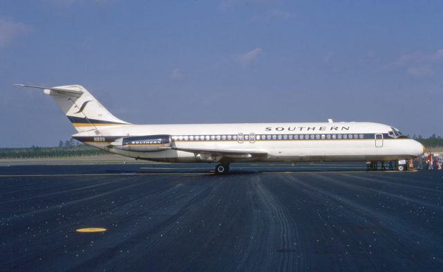
The Crash of Southern Airways flight 932
On the 14th of November in 1970, a McDonnell Douglas DC-9 crashed on final approach to the Huntington Tri-State airport in West Virginia, killing all 75 on board. The aircraft had been chartered as Southern Airways flight 932 to carry the Marshall University Football team, along with their coaches and fans (known as boosters) back home to Huntington after a football game in Greenville, North Carolina, which they lost.
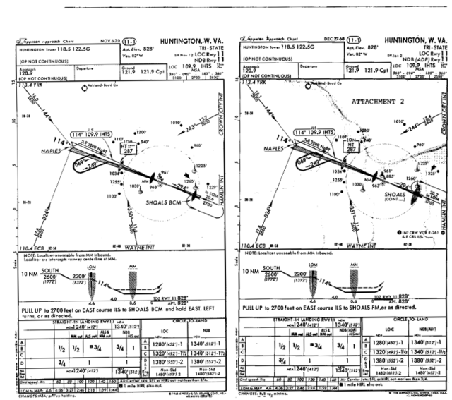
Tri-State airport is surrounded by hills. The runway is 828 feet above mean sea level (amsl). There was a tree to the east of the outer marker at 990 feet amsl. Two rivers passed by the airport at elevations of about 500 feet amsl north, south and west of the airport.
The key point to take away here is that the geography around the runway was uneven, with the elevation ranging between 500 feet and 1,000 feet amsl. At the time, this wasn’t reflected on the charts; the pilots flying that evening probably didn’t know much about the surrounding area.
The weather was 300 feet scattered cloud, 500 feet variable broken ceiling, 1,100 feet overcast with a visibility 5 miles in light rain, fog and smoke. This means that at 600 feet, the flight crew would have struggled to see the ground. With the rain and fog, they might not be able to land at Huntington Tri-State at all, but everyone was hopeful that they would make it home.
In order to land in such conditions, a pilot has to use external navigational aids. In 1970, it was still very expensive for an airport to install Instrument Landing Systems (ILS) for their runways and non-precision approaches were much more common. A non-precision approach is simply an instrument approach to a runway which doesn’t have an instrument landing system. This means that the flight crew aren’t receiving a glide slope that will lead them directly to the runway like they would with an ILS approach. Instead, they use navigation beacons to align the aircraft with the runway and then they follow ‘step downs’ which allow them to descend safely towards the runway. The flight crew remains at a specific step-down altitude until they’ve passed the appropriate point, at which point they descend to the next step-down altitude.
The allows the flight crew to safely approach the airfield even though they are flying above or through clouds and cannot see the surrounding terrain, let alone the airfield.
The crew must remain aware of the minimum descent altitude, which they should not fly below unless they have the landing environment clearly in sight (that is, the runway and surrounding terrain). The approach can continue at that altitude until the ‘missed approach point’. If the flight crew still don’t have the runway in sight when they reach the missed approach point, they have to go around.
At the Tri-State Airport, the minimum descent altitude was 1,240 feet amsl, where the runway was 828 feet amsl. This means that flight crew can continue their approach at 400 feet above the runway threshold until they have the airport in sight, which will keep them clear of terrain. If the flight crew still can’t see the runway when they reach the missed approach point, they break off the approach and turn north while climbing to 3,100 feet. From there, they can either try again, if they think the visibility is improving, or they can divert to an alternative airport: one which has better weather or a runway with an instrument landing system, which will guide them to almost over the threshold even if visibility is bad.
In 1970, the Tri-State airport had a localiser which offered horizontal guidance to the flight crew. Once they are ‘on the localiser’, they know they are flying on the approach path towards the runway. If the airport had an instrument landing system (ILS), then it would also offer vertical guidance to the flight crew. The glide slope indicator in the aircraft would tell them exactly how to follow the path down to the runway to remain clear of terrain and reach the runway at the right height. Because Tri-State airport did not have an ILS, there was no vertical guidance.
There were other external navigational aids available to airports at the time, including Precision Approach Radar and VASI systems. Huntington didn’t have Precision Approach Radar but normally an airport of that size with no ILS would at least have a VASI system.
VASI is a visual approach slope indicator which uses red and white lights to offer visual descent guidance information. The light units are arranged in bars: near, middle and far; most VASI installations are two bars, near and far. The lights should be visible from up to 5 miles (8 km) during the day and up to 20 miles (32 km) at night.
These days, it’s much more common to see a Precision Approach Path Indicator (PAPI) but in the 1970s, the VASI system was much more common. Similar to PAPI, the lights appear as white or red depending on the angle from which it is viewed. If the aircraft is on the glide slope, then the first set of lights (near) should appear white and the second set (far) as red. This visual glide path allows the aircraft to remain safely away from obstructions within 10° of the extended runway centreline.
At the time, FAA policy was to provide VASI systems primarily where no other electronic guidance was planned or available. As the Tri-State airport was actively negotiating for a glide slope for an instrument landing system, no VASI system was installed. There was just one problem with this: they’d been negotiating for thirteen years, since 1957. In the mean time, they had no ILS and no VASI.
The airport lighting system, which consisted of high intensity approach lights, sequence flashers and high intensity runway lights, was operational and it’s been confirmed that on the 14th of November in 1970, everything was properly set.
However, another issue for the flight crew that night was that Tri-State was an off-route airport, which means that it was not an airport that the charter airline trained the crew on or tested them on. There was no standard way that the flight crew could demonstrate that they had sufficiently familiarised themselves with the airport approach. And there was nothing on the charts to warn them about the high terrain as they continued inbound to Tri-State in the rain in the dark.
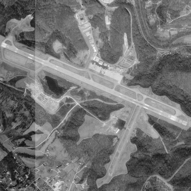
Aerial photo of Tri-State Airport in West Virginia, United States, March 1995
The captain and the first officer chatted about the chart en route; they weren’t worried.
Captain: You might try it again
Sound of tuning of ADF
First Officer: Southern nine thirty two out of eleven thousand five hundred.
Captain: Approach plate’s two years old.
First Officer Yeah [unintelligible]. On these charter kits they don’t keep those things up like they’re supposed to.
Sound of laughter
Captain: How many miles you got to Pulaski?
First Officer: About to run out [unintelligible]. It’s pointing that way Frank. Can’t get a code on it though.
Captain: Let’s run the rest of the in-range check… How many miles you got on it? I [intelligible] it’s gone off.
First Officer: Yeah, it’s gone off. (Bugs) one two three
Captain: Put Charleston on yours [unintelligible]
Captain: Center, Southern nine thirty two
Indianapolis Center: Southern nine thirty two, descend and maintain five thousand, say again.
First Officer: Okay, Southern nine thirty-two, we’re out of eight now, we’re going to five, and approximately how far do you show us from the Huntington Airport?
Indianapolis Center: Nine thirty-two approximately twenty miles south-east of Huntington Airport.
First Officer: Roger.
Indianapolis Center: Southern nine thirty two squawk zero four zero zero, contact Huntington Approach Control one two zero point niner, radar service terminated.
First Officer: One two zero point nine, good day sir.
The fact that the charts didn’t show the terrain shouldn’t really matter. The procedure on the charts was still clear.
The flight crew that night were experienced: the captain had worked for Southern since 1949 and had 18,557 flying hours, the first officer had been hired by Southern five years ago in 1965 and had 5,872 flying hours. Both had rest periods (20 and 18 hours respectively) before reporting for duty.
So it isn’t surprising that they weren’t all that worried about the chart. The big question from the pilots’ point of view was whether they’d be able to get into the airfield at all.
The weather was 300 feet scattered, 500 feet broken, 1,100 feet overcast, with a visibility of five miles in the rain and fog. This means that at 600 feet, the flight crew would have struggled to see the ground. Once the crew descended to four hundred feet over the runway height, they could not descend further unless they were in clear sight of the runway.
As they approached the airfield. a previous aircraft reported that they broke out of the clouds right at four hundred feet and were able to land. It seemed hopeful that they would, as well, allowing Southern 932 to continue the approach and land.
Today, flight crew are told to keep a sterile cockpit, where they avoid any discussion and distractions that aren’t directly related the approach. But in 1970, this wasn’t a concept that anyone had heard of and it wasn’t really seen as a big deal that the flight crew were chatting during critical phases of flight.
Even so, on that cloudy night, it was particularly bad, because the charter coordinator was also in the cockpit, a break in procedure which wasn’t acceptable even then. Worse, he seemed not to care that the approach needed the pilots’ full concentration as he chatted to them, talking about picking up fuel in Huntington.
First Officer: Forty-two DME. How many you got?
Captain: Thirty-seven. Coming over middle marker.
First officer: Middle marker there.
Charter Coordinator: Frank, you want full fuel load out of here?
Captain: Might as well.
First Officer: Minimum is nineteen —- wonder how much they’ll charge us?
Charter Coordinator: Well, we get contract price, whatever that is, whatever we pay for it.
First Officer: We got a mile or two to go, Frank, ‘s all
Captain: We’re showing on the localizer
Charter Coordinator: Hope we don’t have this all the way in. It’s rough.
First Officer: There she is.
First Officer: Southern nine thirty two, we’re over the marker now, proceeding outbound.
Huntington Approach Control: Southern nine thirty-two, roger, report the marker inbound.
The lack of focus becomes obvious when the captain said, with surprise in his voice, that he had captured the glideslope. He was right to be surprised. Tri-State did not have an Instrument Landing System and there was no glideslope.
Captain: That thing captured! How did it capture?
First Officer: Yeah, it ought to.
Captain: You getting a glide slope capture and you ain’t got a glide slope.
First Officer: I might capture on the, ah, on ILS, ah, Frank, regardless of glide slope. I don’t have no capture, though.
Captain: Okay, give me twenty five
First Officer: Yeah, it’s good, it’s got the capture.
Captain: I got it cut off there now.
First Officer: Got twenty-five flaps, all is squared.
Captain: We ought to be over the outer marker at twenty — two hundred feet
First Officer: Yeah.
There is no ILS at the airport so they do not have a capture of anything.
Charter Coordinator: I’m sorry, Frank.
Captain: You going to call out minimums?
First Officer: Yeah, I sure will. I’ll sing ’em out to you.
There was no glide slope. The captain must have set up the instruments wrong; it seems likely that he was seeing the ‘automatic descent’ which is a standard descent of 700-800 feet per minute. This had nothing to do with the actual sector that he was in and it was in no way safe to follow the slope down.
Now, as long as the flight crew were still monitoring their altitude separately and following the non-precision step-downs, that wouldn’t matter. But instead, the captain became fixated on the (fake) glideslope and the autopilot. Both of the flight crew stopped paying attention to the step-downs.
The first officer continued to monitor the instruments as they descended into the dark, unaware of the rising terrain surrounding their destination.
First Officer: A thousand feet above the ground, rate and speed good.
First Officer: Speed a little fast, looks good. Got bug and twelve.
Captain: See something?
First Officer: No, not yet. It’s beginning to lighten up a little bit on the ground here at ah… seven hundred feet.
First Officer: Bug and five.
First Officer: We’re two hundred above.
Charter Coordinator: Bet it’ll be a missed approach.
By two hundred above, the first officer probably meant that they were 200 feet above the minimum descent altitude. The minimum descent altitude for Huntington was 1,240 feet above mean sea level or 400 feet above the runway height. The Charter Coordinator still hasn’t learned when to shut up.
Following procedure, they can descend another two hundred feet and then they continue to fly at 400 feet above the ground until they make visual contact with the runway.
A few seconds later, the first officer called out “Four hundred”, which presumably was meant to that they had reached the minimum descent altitude of four hundred feet above the ground.
Captain: That the approach?
First Officer: Yeah.
This sounds to me like the captain was asking if they reached the minimum descent altitude, which they had. The first officer confirmed and the aircraft began to level off.
Normally, the captain would have anticipated reaching the minimum descent altitude when the first officer called two hundred above, so that he would be levelled off by the time they reached it. Instead, he didn’t start leveling off until the first officer called four hundred feet. The aircraft sank an additional ninety feet.
Here’s the big question: what, exactly, did the call-outs mean? My first impression was that they make a lot more sense if the first officer was using the radio altimeter rather than the barometric altimeter. The barometric altimeter would have been set to show them their altitude above sea level. The radio altimeter times how long it takes radio waves to reflect off the ground, so it gives the “true” height because it is measuring the distance between the aircraft (or specifically, the antenna) and the ground directly below it.
The radio altimeter is only useful over a short range but it is extremely useful for maintaining an exact height above the terrain below, an issue which we looked at in the case of Air France flight 296 at Habsheim.
But on this foggy night, they were flying over rapidly changing terrain. In this scenario, it is much more useful to know your height over mean sea level, rather than know that you are 400 feet over whatever it was you just flew over, without knowing if it was a hill or a valley. For this approach, the barometric altimeter makes a lot more sense.
From the report:
Southern’s training program distinguished between the use of radio altimeters in instrument approaches over level and irregular terrain. However, the Southern Airways DC-9 Operating Manual did not make such a distinction, but rather accentuated its use for all instrument approaches by stating that, “Two separate radio altimeter systems…are provided to obtain precise altitude information above the ground at minimum decision [sic] altitude (MDA). This information is essential to the pilot in his decision to land or initiate a go-around maneuver.”
(Long term readers will know that I had a bad habit of talking about minimum decision altitude when I meant minimum descent altitude, so I’m kinda pleased to see that I’m not the only one…)
Notwithstanding the fact that the crew may have been formally trained to use the radio altimeter as a secondary reference, the tabulation comparing the available altitude references indicated that the first officer may have relied on the written material and was using the radio altimeter for altitude information.
It’s not possible to be sure what they were thinking. There is no clear evidence of any malfunction. The captain could have seen the dim glow of the approach lights through the weather, although the investigators think it was unlikely. Certainly the captain never said that he had the runway in sight. There was never a vocalised positive decision to continue the descent past the minimum descent altitude.
Nevertheless, by the time the aircraft was two miles out, they were 300 feet below the minimum descent altitude. The flight crew didn’t seem to be aware that they had descended past it. As the DC-9 came clear of the cloud, they discussed the lights just beginning to become visible in the distance, probably the glow from the refinery lights.
First Officer: Hundred and twenty six.
In a modern airline, the first officer is trained to be forceful, especially when he notices something wrong. Something like the fact that they are dangerously below the minimum descent altitude and no one has called out that the runway is in sight.
These days, we’d expect the first officer to make a direct instruction: WATCH HEIGHT! FULL POWER! GO AROUND! If the captain still didn’t respond, which can happen when someone is fixated, and the situation did not improve, then the first officer would be expected announce that he was taking control of the aircraft and to put full power on and climb away.
But that’s now, with a much greater understanding of Cockpit Resource Management and the benefit of decades of safety studies. In 1970, the first officer was clearly in a position of being subservient to the captain. He was meant to support him, not to question him. He didn’t have the power to insist on an action or take control of the aircraft. Again, this is similar to the A320 demo flight over Habsheim, in that the Pilot Monitoring, in that case a pilot who was a captain in his own right, was calling out the height but not empowered to take control when the aircraft went dangerously low.
The first officer shouted a single word: hundred. According to the flight data recorder, at this point the DC-9 stopped descending and someone applied power, almost certainly the captain, as not a word was spoken, leading the aircraft to enter a slow climb. Was the captain initiating a go-around? And if so, was the first officer’s shouting out “hundred” referring to their altitude or their airspeed?
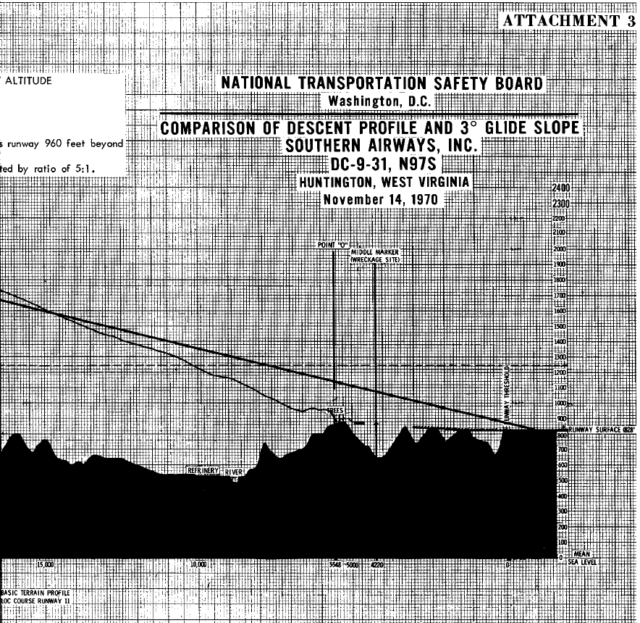
Just over a mile west of the runway, there was a hill with a tree. The top of the tree was at 990 feet above mean sea level; 150 feet higher than the runway, which was at 828 feet above mean sea level.
With a minimum descent altitude of 1,240 feet amsl, they would have cleared the tree by 250 feet. If they’d had the runway in sight, they would have seen the silhouette of the tree, a clear obstacle blocking out the runway lights.
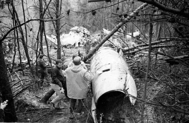
Instead, they flew right into it. The aircraft dipped to the right, almost inverted, and then crashed nose-first into a hollow. As it hit the ground, the aircraft burst into flames, an intense fire that reduced the fuselage to a powder-like substance. There was never an opportunity to evacuate and no chance of survival.
The increase in power and halting the descent imply that the captain had decided to go around, which fits in with the swath cut through the trees. But it was too late.
The Aircraft Accident Report AAR73-11 concluded only that the aircraft had descended into the tree.
The National Transportation Safety Board determines that the probable cause of this accident was the descent below Minimum Descent Altitude during a non-precision approach under adverse operating conditions, without visual contact with the runway environment. The Board has been unable to determine the reason for this descent although the two most likely explanations are (a) improper use of cockpit instrumentation data, or (b) an altimetry system error.
The two explanations are both interesting and both hard to believe. I look at them in more detail in Part 2: An Analysis.


Hmm, the radalt theory conflicts with the descent profile graph, because it shows the aircraft leveling off near 400 ft above the threshold and not 400 ft above the refinery/river. It’ll be interesting to see what Sylvia makes of it in the second installment.
I had a peek at the CVR transcript, and it both mentions the autopilot not working as expected, and a “downdraft” making the plane descend faster. It makes me wonder.
I am also surprised that the FO seems to have missed the descent from 400 ft above threshold to 100 ft. He can’t have been monitoring then instruments very well; I expect he had his eyes outside, trying to see the airport? Today, I think procedure is for the PF to look for the runway, and the PM to keep monitoring the instruments. With that separation of duties, the approach would have been safer.
Sports teams seem to crash regularly, at least they used to (there’s a wikipedia page dedicated to that!); in fact, another team from Wichita State University had crashed the previous month. Thankfully, the only crash listed for the past 8 years was LaMia flight 3933, where a Brazilian team crashed in Columbia when their Venezuelan aircraft ran out of fuel.
There’s an old joke about transporting sports teams: on one such flight, the team was making quite a ruckus in the cabin; the captain had already tried to calm them down, to no avail. The FO left the cockpit to talk to the players, and when she returned, everything was quiet in the back. “How did you do that?”, wondered the captain. “That was easy”, replied the FO, “I just told them, look, the sun is out, why don’t you take your ball and play outside for a while?”
The whole time I was reading this, I was hearing Bitching Betty going “TERRAIN. PULL UP. TERRAIN. PULL UP.”
A modern TAWS would know when they’re below the glide path, and where the mountain is, but one of the older GPWS systems, like they were introduced in the 70ies? With the gear down and the spoilers armed, how much would it have complained?
GPWS did not exist yet, that’s one of the important effects that this crash had on aviation (I’ll get to that too, I hope)
I learned a few new acronyms in this post, which made it all the more interesting. I’m surprised the tree didn’t have lights on it. Seems like it would have been useful in exactly these conditions.
I remember this crash quite well, although for unusual reasons.
Early in the school year of Autumn, 1970, I suffered a burst appendix and was in a life or death battle with peritonitis. When I came out of it, I fought my way back to health, exercising, eating carefully and for months afterward I found that I needed a lot of rest. So I took refuge in my bedroom and listened to my radio for an hour or two before falling asleep. There were some good songs, that Autumn and that radio became much of my world.
I had returned to school on a limited basis, and was taking an “Aviation” class; basically Private Pilot ground school. So one night, with aviation terms dancing in my head, I heard that a plane had crashed and that an entire college football team had been killed. The story played out course of some days, and being somewhat confined, I heard the news reports every night, so I followed the story more closely than my juvenile attention span would have otherwise allowed.
Perhaps it was my own brush with death, but I recall being affected by it and like that it was part of my life, even though West Virginia was unimaginably far to the east. I think the striking thing was that many of the victims were “kids”, just a few years older than I. Mortality is not a fun thing to learn about.
Now, nearly 50 years later, reading this analysis, I see how easily mortality can make its presence felt. In one sense, it was very simple; an airplane making a landing in bad weather with limited visibility hit the terrain. Perhaps most striking to me is the fact that it was a unfamiliar airport. Even in VFR conditions, an unfamiliar airport raises the level of the challenge and in IFR conditions with an approach that only gives horizontal guidance the level of challenge rises further.
Like so many crashes, it’s easy to second guess in retrospect but it sounds like communications and distraction played a major role. Its amazing how simple problems can cascade into tragedy.
That’s fascinating. I can imagine how that could end up being formative (I feel much the same about the Cerritos crash).
Minor note: “fans” are people who follow what a team does; “boosters” are people who encourage other people to be fans. The passengers who weren’t team members or functionaries would have been especially noisy boosters, e.g. people who sold a large number of tickets to every game; with such a mix, it wouldn’t have been surprising if the passenger area got a little rowdy (although that doesn’t seem to have been an issue here).
My first question on this mess would be how familiar these pilots were with non-precision approaches. I recall reading about TWA flight 514, which hit the far side of a ridge some miles from IAD, back when the crosswind runway didn’t have a precision approach (as I understand it does now); there was some criticism of standard ATC terminology, but the transcript I saw at the time suggested the pilots didn’t know whether to descend to a given altitude before or after a given fix. Charter pilots might or might not be more used to flying into underequipped airports; the investigation report for this accident will be interesting.
None of which mitigates the effect of having someone in the cockpit who wasn’t involved in flying the airplane; I hadn’t realized that “sterile cockpit” procedures were developed later, or that a captain would not have told the interloper to shut up even without prompting from the more-subordinate co-pilot of the time.
@Mike S: somebody would have had to run power to the tree; a radio mast already has waveguides (and maybe power for antenna heaters) going to it, so adding lights isn’t as complicated. I wonder whether standards are different today, such that a nearby obstacle would be lowered and/or marked.
Oh, I did wonder about the boosters! Thank you for that. And good point about needing to know more about the crew’s experience.
A shocking litany of poor airmanship. One wonders what the standards were in the airline: Even in the 70s airlines used to have better cockpit discipline than what is displayed here: OK, no “sterile cockpit”, but the crew seemed to lack coherence. No GPWS, I am not certain when they became compulsory but out-of-date charts do not point to a well-run operation.
Nowhere do I read anything about a crew briefing. It was already in my days normal practice to go over the approach, procedure and navigational aids, aircraft weight, flap- and bug settings, missed approach, remaining fuel (how long can we hold before we must divert?). It all seemed very casual.
Sylvia, the charts DID show the terrain. Jeppesen is always meticulous.
Look above the box showing the diagrams: on the right you see “MSA”, minimum sector altitude. It indicates sectors, based on the airport reference point, with the minimum safe altitude in each sector. In addition, there are “spot heights”: black dots with individual heights for the obstacle they represent. Any experienced pilot will know this. The Jeppesen system has been used by virtually all operators.
In Germany they have Bottlang, the UK had Aerad, KLM had (probably still have) their own charts. Jeppesen is serving nearly all airports, large and small. An airline like KLM dispenses with charts for airport that they never will use.
OK, follow me – and the doomed flight – as I am trying to reconstruct their track, they are arriving from the south-east. The crew are still chatting. Indianapolis hands them to Huntingdon, presumably they are “cleared for the approach”. They probably are tracking towards the LOM, the “HT” NDB. Presumably overflying the airport and continuing on a reciprocal from the approach. There is no DME listed, the approach depends to a degree on timing. No big deal, this is – at least on paper – an experienced crew.
As they overfly the MM, the jumpseat passenger starts a discussion about fuel uplift. This is the moment when the captain should have told the coordinator to remain silent. I may have used the words “shut up or leave the cockpit”. There is not mention of any checklists being read, but maybe that bit was left out?
The flight is now tracking to the NDB and according to the chart allowed to descend to 2600 feet. They are receiving a DME, I cannot see from which VOR but that is not really important.
Reporting the beacon “outbound” means that they have overflown it, flying in the opposite direction of the approach. About 30-45 seconds after passing the NDB they will make a procedure turn, turning left on heading 249 (indicated “south” on the chart) for a minute and turn right on 064 degrees to intercept the localizer. Certainly during the course reversal turn they should have been at the initial platform height of 2600 feet. Aided by the NDB the flight now intercept the LLZ inbourd and extend initial flap setting and the landing gear. The crew should have completed the approach checks a long time ago.
Once established, the crew then should descend to 2200 feet, passing the NDB, now “inbound”, they were allowed to descend to the MDA and complete the final checks.
After about 30-45 seconds max when passing the MM, if no sufficient visual contact with runway or approach lights, a missed approach should have been initiated.
They never got that far. What happened? How could an experienced crew fail to understand that they were intercepting a false glideslope? They were on a non-precision approach. They were no beginners, Sylvia writes here that the captain had been with the airline for 21 years and had accumulated 18,557 hours. The F/O was no rookie, either.
A radio altimeter is not used to determe the MDA or DH other than in Cat 2 or Cat 3 approaches, when the corresponding heights are marked on the approach charts..
A mystery or a very sloppy, complacent crew? I do not really like to give an opinion like this, but unless other facts emerge, this seems the only conclusion.
Thank you, Rudy, that’s quite helpful!
The crew does coordinate somewhat as to the navigational aids, the state of the airplane, the captain asks the FO for the missed approach procedure and he reads it out, and at one point the FO sems to go through a checklist: “Okay, you got the no smoking, ignition, radar standby, automatic shutoff armed, waiting on the gear —– got the spoilers?” It seems a bit informal, though.
GPWS became mandatory 4 years later. My question is, the GPWS doesn’t warn when the aircraft “hits” the runway, right? How does it know that? When the plane is configured for landing, as it was here, gear down and flaps 25, would an old-style GPWS have warned about the terrain? Or would it have been in “landing” mode and stayed silent?
I find it very significant that every single altitude call out given by the FO was given in feet above the ground, not MSL. Why? I see this as very strong evidence that he was referencing altitude by the radio altimeter only and ignoring the barometric altitude. Height above the ground has zero relevance. Adherence to MSL altitudes published on the IAP chart means everything.
He may have been talking about height above the threshold, which makes sense if you have the glidepath in mind.
When on a non-precision approach, even a cat-1 ILS, the rad-alt is only a bit of extra information. It reacts to the terrain directly below the aircraft, there are airports in the world that are actually on high ground, with much lower terrain in the approach area. So if the runway is, let’s say 500 feet higher than the surface before it then on an ILS with a DH of 200 feet, it would read 800 or 900 just before and suddenly, at DH, fall back to 200.
The GPWS reacts to a number of inputs, closing rate to terrain being one of them, triggering “sink rate, sink rate, pull up”. But Mendel is right: in landing configuration and no excessive rate of descent it is unlikely that it would have triggered an alert.
“Ok you got the no smoking, etc.” is not really a formal checklist, not in my book. It is sloppy and raises the risk of missing an item.
Once, taxying out at Dublin Airport, we had a stuck mike whilst reading the checklist. After we realised it and sorted it out, the dry comment of an Aer Lingus pilot was “at least you read the checklist properly”.
Haha!
Just for completion’s sake: This accident happened during a LLZ (Localizer) approach. Although there is no glideslope, the frequencies of localizers are the same as those of an ILS. So accurate laterally and from Sylvia’s transcript it emerges that the crew were well aware of it: they were remarking that “… you getting a glide slope capture and you ain’t got a glide slope.” Next, they remark that they should be over the marker “…at twenty-two hundred.” All they had to do, even on the autopilot, would have been to descend to 2200, engage “alt. hold” and descend to MDA after passing the LOM.
Until the marker, usually depending on aircraft type and company procedures, an intermediate flap setting should have been used with the final settings after passing the marker.
The approach was not really all that demanding, not even a missed approach if they had been prepared, but I do not seeany mention of a crew briefing in the transcripts. So, barring other evidence to the contrary, the inevitable conclusion still must be that cockpit crew coordination was sloppy, the crew were distracted and barely “in the loop”, leading to this tragedy.
I remember reading an article about this tragedy several years ago. The article talked about many children were left parent less because many boosters where couples. A very traumatic event that took the air out of Marshall University for several years.
Just a minor pick. We here in the United States would call if a football “game” not a “match”. Though I realize your audience maybe mainly Europeans.
Oh, no, that’s a good point. I am all for minor picks.
I hadn’t thought about the boosters-as-couples aspect; very sad.