
Flightradar 24 and aircraft tracking
Flightradar24 (FR24) is a global flight tracking site which offers realtime information about flights by tracking ADS-B. ADS-B stands for automatic dependent surveillance-broadcast. This is a means for an aircraft to automatically transmit its identification and location, allowing other aircraft and aerodromes to know where they are. What’s great for us is that because it is a broadcast, anyone can read the data, which allows us to track their movements. It can make for addictive watching.
For example, today the Antonov An-225 departed Ireland to return to the Ukraine. It was possible to watch the flight across Europe in real time on the site. Also, now that it has safely arrived in Kyiv, you can still watch the playback of the flight on their website.
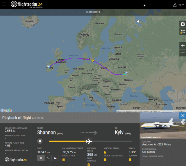
You can access playbacks on the site by clicking the clock icon on the right side of the flightradar24.com page or search for a flight number to watch a specific flight.
These screenshots from the site show the difference in transatlantic traffic in 2019 and 2020 for the 6th of June at 0300 UTC:
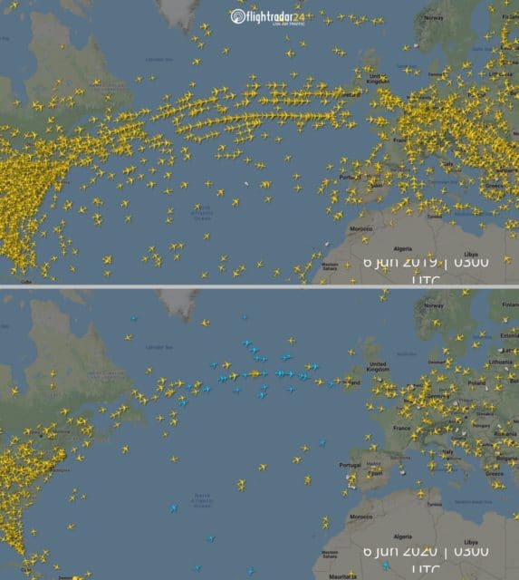
The blue planes, by the way, are those tracked by satellite.
Satellites are collecting the ADS-B signals from aircraft and transmitting them to the Flightradar24 network. Space-based ADS-B tracking will be used to supplement our terrestrial receiver network.
ADS-B signals are sent out from the aircraft and collected by satellites orbiting the earth. The signals are then transmitted to ground stations and the Flightradar24 network. All of this occurs in near real time.
ADS-B signals have a limited range and terrestrial stations are incapable of coverage over the oceans and in remote areas without power and internet. Using satellites to collect ADS-B signals allows us to cover these areas efficiently and supplement our existing world-leading terrestrial receiver network.
Obviously, Flightradar24 also gives us a great view of historical situations, for example, the disruption caused by the Eyjafjallajökull volcano in April 2010. This visualisation, based on Flightradar24 data, shows quiet airspace followed by flights slowly increasing after the eruption.
Airspace Rebooted from ItoWorld on Vimeo.
You can also impress your friends and family with the phone app (Android and iOS) which uses your location to identify aircraft overhead. Simply point the phone at the plane and the app will tell you the flight number and aircraft type and, for commercial flights, the routing.
(OK, my friends and family have never been impressed by my naming every flight as it flies overhead but I live in hope.)
There are entire communities dedicated to watching the tracked flights and discussing what they’ve seen. Which sort of feeds on itself, because flight crew know the world is watching. Like this FEDEX flight whose ADS B info was clearly entered by a disgruntled pilot:
FUCKYOU
…the movie! 😳😂@FedEx N819FX pic.twitter.com/6YaPeUYRZB
— CivMilAir ✈ (@CivMilAir) April 6, 2019
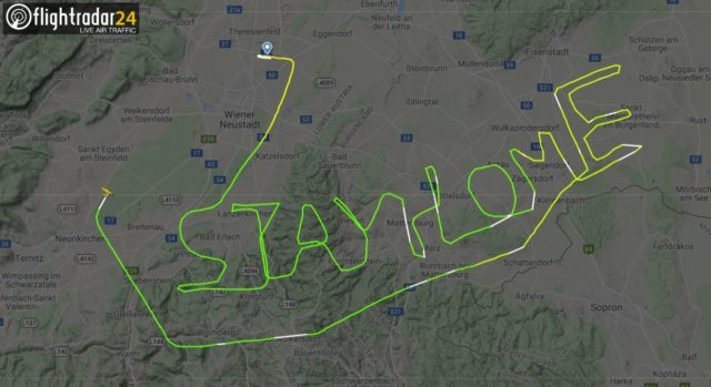
And, of course, Flightradar24 is generally the source of pilot performance art, where the flight routing is specifically planned to create an image that can be seen only through tracking. Mostly rude, of course, but they are often funny and sometimes even a public service announcement.
There are some common questions that get asked over and over again. New users are intrigued by strange flight patterns which, if you are used to aviation and Flightradar24 tracking, aren’t that strange at all. Planes don’t always fly in straight lines but that comes as a surprise to those who only think of them as commercial passenger and cargo flights.
Which brings me to the point of this post. I’m thrilled to see that Reddit user derekcz has taken it upon himself to help people out by making this handy-dandy graphic to answer the most common questions which he has seen about aircraft trajectories on Flightradar24.
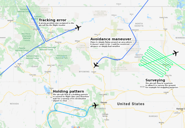
In the comments of that post, one user points out that she’s seen a “hole” in the aircraft pattern where aircraft didn’t fly. It wasn’t a military installation and she wondered why this area was avoided. It turned out that an air traffic controller had been confirmed as infected by COVID-19; flights which would have been managed by that part of the facility were re-routed to avoid the region while the facility was decontaminated.
I find this endlessly fascinating. If you do too, I’d love it if you would share your favourite flight tracking links and stories in the comments.


The Mediterranean Fruit Fly Preventive Release Program releases sterile frut flies from the air to prevent fruit flies from breeding and damaging crops in California and Florida. The service leases a few Beech Barons with chutes in the bottom where the operators simply dump these flies from about 2000′ height AGL out of the bottom of the aircraft. The flight pattern of these operations are the same as for survey flights, because obviously they have to cover an area.
It’s useful to understand that the ADS-B data originates with the aircraft; if for example the altimeter is not working right, the reported altitude will be wrong in the ADS-B data. That’s a big difference from actual radar, and has caused accidents in the past.
The ADS-B is transferred in pieces by radio, and therefore information can get lost due to radio interference. This was an issue in analysing the tracking information from the Calabasas helicopter crash in January: as the helicopter flew low among the hills, the FR24 receivers did not catch all of the datagrams, and would put older pieces of altitude data together with newer pieces of location data, and the FR24 servers would receive several of these time-crossed pieces of information from different volunteer receivers, which made for apparent “jumps” in the flight data.
ADS-B transmissions from low-altitude flights or in obstructed or simply lonely areas might not get picked up by FR24’s receivers, leading to gaps in the flight paths. The satellite technology mitigates that somewhat, but an aircraft needs a newer ADS-B transmitter that uses the frequency that the satellite listens on to take advantage, and I expect an ADS-B antenna on top of the aircaft also helps.
The new ADS-B services are two-way; aircraft can receive information such as weather reports from ADS-B ground stations. This technology has come a long way from the simple transponders of the past!
All good points although I was thrown by the fruit flies for a moment there; I get spam that starts like that. :D
“ADS-B stands for automatic dependent surveillance-broadcast which is how aircraft determine their position using satellite navigation. What’s great for us is that most aircraft also broadcast this information, which allows us to track their movements.”
This is a bit confusing. Aircraft determine their positions using GPS, DME, VOR, INS and so on, not by ADS-B. They then broadcast their position (and other information) using ADS-B. I.e, ADS-B is on the output side rather than the input side as far as a particular aircraft’s own position is concerned. Obviously, aircraft can also receive ADS-B information from other aircraft in their area.
I added that at the last minute when I realised I’d not at any point defined the term. You are right and I have fixed it.
AN225: Big bird is being watched!
Thanks Sylvia for all that. With increasingly sophisticated technology Big Brother is watching us, continuously.
The flipside is that our phone not only allows us to watch aircraft and, I am in no doubt, also commercial shipping.
And it also watches US ! Your phone knows exactly where you are, or at least, where you left it.
That may come handy if youj lost it, but:
Privacy is becoming a thing of the past, there are always two sides to a story.
Oh, btw: Sylvia mentions that “an Antonov AN 225 departed from Ireland”.
Yes, I know it is pedantic, but it should be THE AN-225.
There was only one ever built.
Gah, yes, fair point.
https://www.buryfreepress.co.uk/news/plane-spotted-zig-zagging-over-suffolk-explained-9107545/
An interesting set of aerial surveying tracks is reported on in this linked article.
As a swede I am proud to see how Flightradar24 started as a hobby project by two aviation geeks here in Sweden and grew to what it is today. The company is based in Stockholm and has around 25 employees (August 2019).
Flightradar24 has a network of more than 20,000 ADS-B receivers around the world that receive flight information from aircrafts with ADS-B transponders. The receivers are hosted by volunteers with systems which constantly feed the network with data. A number of different sources are used to present data about the flight; for example picture and age of the individual aircraft.
I am missing the obvious “missed approach/go-around” graphic, where FR24’s graph looks like an aircraft has landed but is instantly seen departing in the very same direction, distinguishable only by the track’s color and the fact it perfectly aligns with an aerodrome’s runway.
But maybe that part is way too obvious to specifically mention on such a graphic.
It might be noteworthy my four year old child does actually enjoy watching FR24 just for the sake of doing so way more than I do…
Been an aviation enthusiast for over 60yr. Didn’t know about this app. Just downloaded it to my iPhone. Should add another dimension to my vhf radio.
Retired from Northwest Airlines over a decade ago; the airline retired about the time I did. Not a pilot but did most of the ground-pounder jobs (ramp agent, fuelling, maintenance, etc). Unless you want to count the private flying. Don’t do that anymore, either. But this will fill some of my idle time