
“Um, have you landed?” Southwest 4013
Flight SWA4013 was a Southwest Airlines scheduled passenger service from Chicago, Illinois to Branson, Missouri. The incident occurred on the 14th of January, 2014.
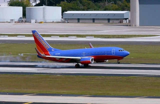
The aircraft was a Boeing 737-7H4 registration N272WN.
In the cockpit was
- the captain, who was Pilot Monitoring,
- the first officer, who was Pilot Flying,
- a company dispatcher who observed from the flight deck jumpseat.
Flight SWA4013 departed late that evening; however the departure and initial climb were uneventful.
As they climbed away from Chicago, the flight crew discussed their destination at Branson Airport (BBG). The captain had never flown into Branson and first officer had only been to the airfield once before, using runway 32.
Based on the wind conditions that night, they agreed that runway 14 would be in use for landing. Runway 14 didn’t have an ILS, so they planned to fly a visual approach backed up by an RNAV instrument approach.
This meant that the Pilot Flying would fly the approach based on being visual with the runway but that the Pilot Monitoring would track the navigation beacons in order to ensure that they remained on course. The navigation display shows the aircraft position, the distance and bearing to the navigation beacon, and the ground speed or time to the navigation beacon.
The captain set up the distance measuring equipment (DME) for the runway 32 localiser. The navigational beacon was located on the far end of their runway, making it trivial to navigate to the right place.
The sun set at about 17:17. At 17:27, the first officer began a standard briefing for the Branson Airport approach. He expected air traffic control to give him radar vectors to the approach and then let the RNAV line them up for a visual. He confirmed that the final approach course was 143° and the elevation at the touchdown point was 1,278 feet above mean sea level. The runway was 7,140 feet (2,176 metres) long. The Boeing 737 requires 4,700 feet (1,432 metres).
The flight crew then discussed the after-landing taxi route to the gate. Initially, the first officer believed they could turn directly off the runway onto the taxi-way back to the gate but after more discussion, the crew agreed that when landing on runway 14, they would need to make that 180° turn.
At 17:44, Springfield Air Traffic Control (ATC) cleared the flight to descend to 24,000 feet. A few minutes later, they cleared the flight direct to Branson Airport. The crew picked up the automated weather report and airport information, which confirmed that runway 14 was in use. As the aircraft descended through 18,000 feet, the first officer called for the descent checklist.
When they were about 60 nautical miles (110 km) northeast of Branson Airport, air traffic control cleared the flight to descend to 4,000 feet and to expect a visual approach to runway 14. The controller told them to proceed directly to the VUCUG waypoint, which is the final approach fix for the RNAV runway 14 approach.
In the cockpit, the flight crew noted that they were putting a 5 and 10 mile ring around “it”, presumably in reference to Branson Airport’s location on their navigation display.
For the next few minutes, all three crew in the cockpit discussed their route and their current location. They compared the navigation fixes and stations on their navigation display to the city lights visible from the flight deck.
They all agreed which lights were Bransom and which lights were Springfield, presumably a reference to Springfield-Branson National Airport, an airport some 50 miles (80 km) to the northwest.
Branson Airport does not have radar monitor capability. Springfield ATC provided the approach services.
At 18:00 Springfield ATC contacted Branson Airport tower to say that SWA4013 was 20 miles northeast of Branson Airport for a visual approach to runway 14.
The first officer said, “Well, I see the beacon down there… No runway yet.”
The captain responded, “I think that’s it. I see a bunch of bright white lights to the right and just a little to the left of the beacon.”
At this point, Springfield ATC interrupted their conversation to advise that the runway was located at eleven o’clock and one five (15) miles.
Now in actual fact, the controller was a bit slapdash. At that point, Branson Airport was almost twenty miles out and really at their ten o’clock position.
The crew continued to discuss the visual references and then the captain responded to Springfield to say that they had the field in sight.
At 18:03, Flight SWA4013 was cleared for a visual approach to runway 14. Springfield ATC terminated the radar service and advised the flight crew to contact Branson Airport Tower, which was expecting their call.
The crew configured the airplane for landing and completed the landing checklist. They exchanged callouts regarding speed, altitude, glidepath and sink rate until they crossed the threshold.
The aircraft touched down at 300 feet past the displaced threshold.
Unfortunately, they were not on runway 14 at Branson Airport (BBG) with 7,140 feet (2,176 metres) for them to come to a halt.
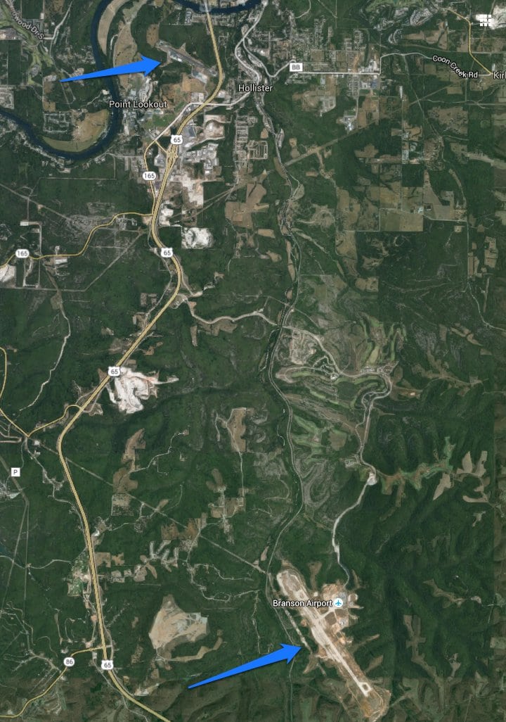
Instead, they were on runway 12 at M. Graham Clark Downtown Airport (PLK), some seven miles (eleven kilometres) north of the Branson Airport.
The runway here was 3,738 feet (1,140 metres), almost half the length that they were expecting.
The dry runway landing distance for the Boeing 737 using maximum manual braking and reverse thrust is 2,820 feet (860 metres) but of course, that’s presuming you are expecting to make a short landing.
In between callouts for the speedbrake, thrust reversers and autobrakes, the captain said “This ain’t it.”
He immediately applied maximum braking. The aircraft came to a stop about 300 feet from the end of the paved surface of runway 12.
Once they had come to a complete halt, the captain contacted Branson Airport tower.
“Tower, Southwest 4013.”
“Southwest 4013, go ahead.”
The captain took a deep breath and came out with it. “Ah, I assume I’m not at your airport.”
There was a long pause.
Branson tower eventually spoke. “Southwest 4013…” Another pause. “Ummm, have you landed?”
“Yeah.”
Another pause. “Southwest 4013, roger.”
I guess there’s not a lot more you can say.
M. Graham Clark Downtown Airport is a busy general aviation airport which services single and multi-engine planes and helicopters. It does not have air traffic control. Airfield lighting is activated by a pilot-controlled lighting system. If the flight crew had been lucky, the lights would have been off and they would never even have known that the airport was there.
The controller at Branson Airport tower said that to save money, he normally kept the runway edge lights off until the aircraft was reported on arrival. There’s no log to show when the runway lights were turned on that night, but the controller believes that he turned them on at 18:00, when he was notified by Springfield ATC that the flight was inbound. Before the lights were turned on, only the runway end identifier lights and the precision approach slope indicator could help the crew locate the airfield.
It was about 1800 when the flight crew were looking out at the city lights and trying to identify the airport. They were cleared for a visual approach at 18:03.
When the ATC controller advised the crew that the runway was located at eleven o’clock and 15 miles out, he inadvertently led them to look almost directly at the Downtown Airport. Branson Airport was slightly to the left: at their ten o’clock position and almost twenty miles out.
The flight crew did notice that they were a little high on the approach and so they widened the base leg. This meant that the approach controller saw the aircraft on what appeared to be a normal flight path into Branson until the aircraft descended to the point that radar contact was lost, which normally happened when aircraft on approach to Branson descended below about 2,600 feet.
The pilots said that once they had the runway in sight, they did not reference any of the on-board navigation.
Thus, they never realised that they were six miles out and twenty degrees off. Obviously on a visual approach, the Pilot Flying must be looking out. However, the captain, as Pilot Monitoring, should have been been monitoring the navigation instruments as a crosscheck. He had set up the DME from the runway 32 localizer specifically to confirm their location and their approach. But instead of monitoring the navigational instruments, the captain used the heads-up display in VMC (Visual Meteorological Conditions) mode. This display offers descent rate information but does not provide navigation or flight director guidance.
And so, there they were.
The tower controller contacted Springfield ATC to try to make sense of what had happened.
“Did you watch Southwest land?”
“Yeah, why?”
“Did you see him come here?”
“Say that again?”
“He said he landed at the wrong airport.”
“Are you kidding?”
“No, I’m not.”
“He dropped off (radar) about over Point Lookout.”
“I think that’s where he landed. I’ll call you back.”
Ground crew were dispatched from Branson airport in order to pick up the passengers and their baggage. I like to imagine that the passengers got to disembark using the slides.
The Boeing 737 was flown out of the airport the following day (empty and without refueling) without any issue despite the short length.
The captain and first officer were removed from flying duties immediately and suspended with full pay pending an internal investigation. The captain has now returned to his flying duties. The first officer elected to retire.
You can read the full NTSB report here: NTSB Identification: DCA14IA037
As a result of this incident, the NTSB has recommended that controllers should withhold landing clearance until the aircraft has passed all other airports that may be confused with the destination airport.


I think I’d go with the First Officer and move along to something else….
Can’t say as I blame him.
Towards the end of the article, the plane is incorrectly referenced as a 777, rather than a 737-700. Please correct this.
Fixed! Thank you very much. I clearly ended up rushing at the end. :(
Sorta apropos considering the subject.
*wince* Touche.
I’ve flown into that airport before. Its on the side of a large hill. Can’t imagine a 737, at night, small airport, terrain, not prepaired, being able to thread the needle. Those people were so lucky to be alive
Yes, considering they didn’t even realise until *after* touchdown, I find it amazing that they stopped with room to spare.
Ouch! 0.0 Well, whenever I’m having really bad day where I’m screwing up all the time; I guess I can take comfort in the fact that even professionally qualified pilots can make monumental cock-ups! :D
This is gold! A veritable text-book CRM case of loss of situational awareness.
It is a perfect illustration why most airlines make if MANDATORY to make use of every nav. aid, even when in VMC and when the crew thinks that they have the airport in sight and want to make a visual approach. More so into an unfamiliar airport. And even totally inexplicable and inexcusable because well before 2014 every aircraft involved in public transport was by law required to be equipped with GPS. This was already the case years before I retired 8 years ago. Even our old Fokker F27’s had GPS.
My very first flight as an acting copilot was in 1968 on a Curtiss C46 Commando, a ferry flight from Lagos to London. The aircraft had been used during the civil war when the south-east of Nigeria tried to secede, calling itself “Biafra”.
It was the typical “cowboy” operation. A flight plan was filed AFTER departure. A huge canvas tank for extra range was in the cargo hold and one of my duties was to squeeze the last drop of AVGAS 115-145 out of it. (now, the only kind is 100LL but in those days there was also grade 100-130 and in Eastern Europe a Russian grade, if I remember well 95-110. The grades were colour coded. I think green and red, but I can be wrong.The Russian fuel was a drab brown, not confidence-inspiring but we never had problems with it). Our first stop was Ouagadougou, from there a night flight across the Sahara to Marrakech. But when we got in range, Dave Brown (the captain) decided that we could make it to Casablanca, then he changed it to Tangier but again changed his mind and decided on Madrid.
In those days aviation was far less formal. We were vectored to the approach and Dave reported “runway in sight”. But the picture did not look right. I hesitated, but had only 200 hours total. Dave had thousands on all sorts of craft: Constellation, DC3/C47, DC4, a lot in bush-type operations. But nevertheless, he must have been tired. I called to his attention that it looked, well, wrong. Dave pointed to his right where we could clearly see a well-illuminated long runway. I looked left and saw another runway, equally long and well-lit.
Dave was too experienced to ignore a novice co-pilot. With a “Dammit you’re right” he swung the aircraft to the left.
We were destined for Madrid Barajas – where we landed without incident. The other runway was Torrejon, then a military airbase only. It was operational that night as the were doing circuits with fighters.
After a rest, we departed for London Heathrow where we landed without further problems. Dave was getting another co-pilot there and I took my pay and an airline flight to Amsterdam.
Sadly, a year later Dave was lost in Africa flying a Connie.
I am always routed well out of the way of Madrid Barajas! I don’t think they like small aircraft passing through. I did manage to convince myself once that a race track was a small runway and turn left to enter the circuit even though I knew that based on my planning, the airfield should be on my right! I worked out my error and circled to get my bearings but it really made it clear to me how easily one can go wrong!
Oh, one small comment:
I cannot understand how the aircraft was flown out “the next day”.
Clearly, this airport was not approved for aircraft the size of a B737.
During my command training for an airline, we had a discussion about such a situation ( a training exercise on paper only).
Since no pre-calculated performance tables would have existed for this airport, it would have required a special authorisation from the FAA AND, lacking performance tables – RTOW or also called TL tables – a day of very complicated calculations with the aircraft performance section of the AOM and a copy of the AIP. Where I come from, it would have involved CAA inspectors, a survey of the runway, it’s surface and bearing strength, obstacles and probably a crew consisting of factory test pilots or an equally qualified captain.with an experienced first officer of the airline, acceptable to the CAA.
An engineer would have inspected the aircraft before release.
The aircraft would have been grounded for perhaps a week, maybe longer.
In Europe, I doubt that it would have been possible just to fly it out again the next day unless all these formalities had been complied with.
But then, perhaps there were experts available who could do all this within a few hours. I am just surprised that it took only a day.
I was surprised by that – maybe they just wanted it out of the way as quickly as possible before the media got more photographs! I think you are right, that it just happened to be the right people in the right place for a speedy recovery of the aircraft.
This reminds me of the B707 that mistakenly landed at the much smaller general aviation airport in Columbus, Ohio decades ago. They had to remove all the seats and have minimum fuel to fly it out. They renamed the airport cafe, the 707 Lounge.