
The Database Error And The Turkish Airlines Airbus
On the 4th of March 2015 a Turkish Airlines Airbus A330-303 left the runway when landing at Kathmandu. The headlines called it a database error. When I read the accident report, however, I discovered that it wasn’t that simple.
The Captain was 55 years old and had almost 15,000 hours with 1,500 on type: he’d been flying the Airbus 330 for two years. His first officer was 47 with over 7,500 hours, 1,269 of which were on type.
Both had received special purpose training of RNAV/RNP KTM in the simulator three months before the accident. I’ll explain more about RNAV below.
Turkish Airlines is the national flag carrier airline of Turkey. At the time of the incident, it operated scheduled services to 261 destinations in Europe, Asia, Africa, and the Americas, making it the fourth in the world by number of destinations.
Flight TK-726 was going to Tribhuvan International Airport (TIA), the only international airport in Nepal. The runway elevation is 1,340 metres (4,390 feet) above mean sea level. It was the captain’s first flight to this airport.
Runway 02/20 is 3,000 metres (10,000 feet) long. Runway 02 has high-intensity approach runway lighting and equipped with a PAPI.
The flight departed Istanbul carrying 11 crew members and 224 passengers.The flight progressed normally until the final stages.
At midnight UTC, the flight crew attempted to contact Kathmandu Control as they descended to FL 250 (25,000 feet).
Kathmandu Control had not yet started operations that day, as they open at 00:15.
The aircraft continued to try to contact Area Control over the next ten minutes while under control of Varanasi and descending to FL 250. They received no response from Kathmandu Approach until 00:17, at which point the flight crew reported that they were holding over Parsa at FL 270 (27,000 feet).
Kathmandu Approach responded that the airport was closed: visibility was only 100 meters (330 feet). The flight crew reported moderate turbulence in the hold and requested to proceed to Simara, a domestic airport in Nepal about 100 km south of Tribhuvan, which was approved.
But then at 01:05, the visibility at Kathmandu improved to 1,000 metres, which meant that the airport was open again.
Kathmandu Approach contacted flight TK-726 with the news and asked what their intentions were. The flight crew said that they were ready for an RNAV (RNP) APCH for runway 02.
The visibility is important because the flight crew need to be visual with the approach lights of the runway when they reach the Decision Altitude (DA), a specific altitude above mean sea level which is defined in the non-precision approach. If they do not have visual contact with the runway, then they should execute the Missed Approach procedure (also defined in the precision approach) and go around. The DA is the altitude in which a missed approach procedure must be started, it does not preclude the aircraft from descending below that altitude.
The Airbus A333 began its approach and the controller cleared it to land on runway 02. However, the crew couldn’t see the runway and initiated a missed approach. They followed the missed approach procedure, climbing to 10,500 feet.
The aircraft approached the airport again. This time, the flight crew seemed more confident. The captain, who was the Pilot Flying said that he had the runway in sight and although he lost sight of it briefly on final approach, he regained it and decided to continue with the landing.
At 01:58:30, the auto-call out of MINIMUM sounded in the cockpit, meaning they were at the decision altitude and should break off the approach if they were not visual.
The captain responded with “continue until 300 feet.”
Now ‘continue’ is an odd call. ‘Continue’ sounds to me like he was not visual at all and was hoping that by continuing the descent, they would get the runway in sight.
Certainly, at this point of the aircraft’s final approach, the CCTV footage of the runway shows that visibility was pretty much zero. An aircraft taxiing on the parallel taxiway and an army guard at the post near threshold runway 02 also both reported no visibility at all.
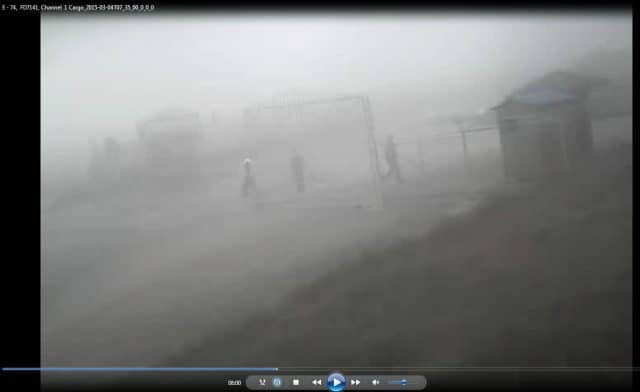
Meanwhile, Kathmandu Tower, who clearly couldn’t see anything either, didn’t comment on the deteriorating weather or mention the fog and mist in the latest forecast.
So, as per his call, they continued the approach past the Decision Altitude.
Now long-standing readers of this blog know I sometimes get confused on this point, so here’s my personal refresher. The Decision Altitude (DA) defines the point at which you should make the decision to carry on or abort the approach. In contrast, Kathmandu’s Minimum Descent Height (MDH) is the specified height above the threshold elevation which you may not descend below without making visual contact.
The aircraft can continue the approach until it reaches the missed approach point, but it must not descend below the MDH.
All the evidence points to much worse visibility than they had on the previous approach, when the flight crew were not able to make visual contact with the runway and executed their missed approach. This time, Airbus was pretty obviously in almost zero visibility and yet they continued, descending past the MDH.
The approach they flew that day was the RNAV (RNP) RWY02 approach. Let’s unpack that.
RNAV is a somewhat unintuitive shortening of area navigation, a method of instrument navigation in which the aircraft chooses a straight course within a network of navigation beacons, rather than navigating directly to and from individual beacons.
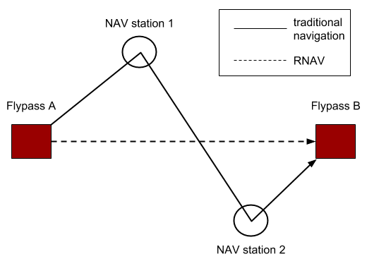
Traditionally, flights would create a zig-zag route using ground-based navigation aids such as VORs and NDBs, often transitting directly over them. With modern onboard navigation equipment, area navigation became possible. An ‘imaginary’ route could easily be plotted using the direction and distance from the navigation aids on the ground to create waypoints leading straight to the destination. In modern terms, RNAV is often used to refer to ‘straight line’ navigation in general, such as GPS.
RNP refers to required navigation performance, which is a specification for on-board performance monitoring and alerting. This includes the ability to follow a specific ground track and follow altitude constraints or even a specific vertical angle. In effect, it allows for a very specific path between the imaginary points. RNP systems offer significant safety benefits and also are efficient, as they allow for closer route spacing.
At Kathmandu Airport, the RNAV (RNP) Instrument Approach Procedure for runway 02 specifies the approach for aircraft arriving from the west, south and east sectors through a series of waypoints.
The aircraft on this approach flies to the RATAN fix and then, after clearance by ATC, continues to the Initial Fix at 8,700 feet and then continue to the Final Approach Fix with full landing configuration until reaching the minimum descent height.
If the flight crew is not visual, then they initiate the missed approach at the Missed Approach Point (MAP) and climb away to the designated height and waypoint.
The Missed Approach Point (MAP) is the last point of the approach. At Kathmandu, it is at the threshold runway 02. Well, it’s meant to be, anyway.
Here’s where our database error comes in.
Kathmandu had plans to extend runway 02 and on the 1st of Jan, 2015, the Civil Aviation Authority of Nepal published a supplement in preparation for this. The supplement specified that the existing threshold would be displaced 120 metres (~400 feet) north of runway 02 (and the approach lighting system decommissioned) as of the 5th of February, 2015.
The runway threshold coordinates were 27°41’02.007’’N 085°21’12.215’’E.
The coordinates given for the displaced threshold, however, were not on the runway centreline but instead offset by about 26 metres (85 feet) to the left: 27°41’06”N 085°21’13”E.
Another supplement was issued on the 29th of January to correct errors, but the coordinates of the runway threshold 02 and the effective date remained unchanged.
This led to the flight management system navigational database, in use in March 2015, to give the wrong coordinates for the runway threshold in the RNAV (RNP) RWY02 approach.
On the 4th of February, a notice to airmen (NOTAM) was released, cancelling the supplement. More specifically, it noted that the supplement was not in effect from the 5th of February to the 4th of March as previously announced.
This NOTAM was not reflected in the FMS navigational database.
Another NOTAM was issued on the 1st of March to cancel the supplement until the 4th of April… but that was way too late for the database which was in use on the 4th of March.
The point is that changes to the Aeronautical Information are (usually) published well in advance of any changes so that the users (that is, the airlines and their flight crew) can update their flight management systems. The flight management systems get updated information every 28 days or 56 days, depending on the cycle used.
The Civil Aviation Authority of Nepal never considered the cycle of revisions and updates when they cancelled the AIP supplement using NOTAMS.
Meanwhile, back in our Airbus, as far as the Flight Management System was concerned, the runway threshold had been moved north (as per the proposed changes which hadn’t happened) and to the left (as per the error). So that’s where it guided the flight into.
Technically, the flight crew should have been aware of all NOTAMS. But I think that as the NOTAM simply said that the works were not being carried out yet, the operator and flight crew could be forgiven for not understanding the implications. The NOTAM did not make it clear that the runway threshold was not as expected and the issues did not consider that an airline’s Flight Management System might now have the wrong coordinates.
And of course, no one had spotted that the coordinates were offset from the centreline.
The end result: the threshold of Runway 02 was never physically displaced but the navigation databases were modified to show that it was.
Pilots flying into the airport obviously noticed the discrepancy. Two days before the accident, the flight crew of the Turkish Airlines flight to Kathmandu reported that, although the navigational accuracy appeared to be correct, the real aircraft position when reaching the Missed Approach Point at the runway threshold was high and offset to the left.
Coming into Kathmandu in visual conditions, it was easy to correct the approach. But as we know, on the 5th of March, conditions were terrible. And this was the captain’s first trip to Kathmandu.
And so, they continued. At 783 feet above ground level, the flight crew asked Kathmandu Tower if the approach lights were on (they were and at full intensity).
A review of CCTV camera footage, installed at different locations of airside areas showed that the weather had deteriorated during the second approach into Kathmandu as compared to the first approach. Landing clearance was issued by the Kathmandu Tower at 01:55:48 hours. At that time it was observed from the CCTV camera footage that the visibility already started deteriorating and by the time of landing the visibility was well below the prescribed minima. The tower did not provide the deterioration in visibility to the aircraft.
The captain continued, leaving the aircraft on the autopilot until they were just 14 feet above ground level. Then the flight crew disconnected the autopilot and attempted to flare.
Now, I don’t care how often that captain says he was visual. If they could have seen the runway, they would have seen that it wasn’t where they thought it was. But they were clearly working off where the runway should be and over that threshold is exactly where they flared.
Five seconds before they touched down, the captain calls ‘appearing’. This is the first recorded reference of the runway being visual. Of course, by now it was much too late.
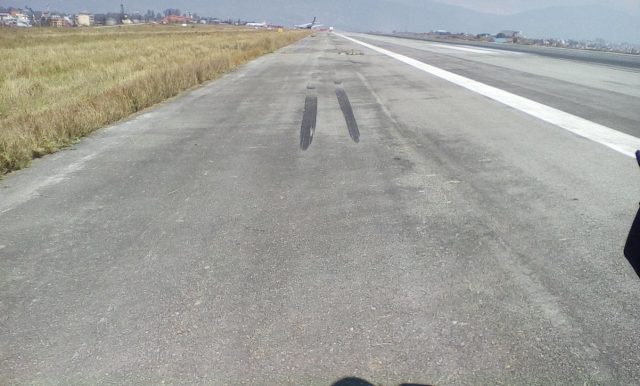
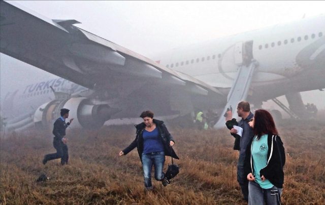
Flight TK-726 touched down to the left of the runway, with the left-hand main gear completely off of the paved surface of the runway. The grassy area alongside the runway was soft and muddy from the rain. The left landing gear dug into the grass, forcing the aircraft to veer to the left.
The wheels broke out and off from the hubs of the left main landing gear.
A soldier at the security post near the runway threshold heard unusual loud sounds but the fog was so thick, he could not see the Airbus.
The nose gear entered the grassy area and soon after the right landing gear followed it off the runway.
The aircraft bounced off the runway and crossed a taxiway The nose gear collapsed. The aircraft nose dragged along the grass. Three wheels on the right landing gear broke and both engines scraped across the concrete as they crossed a second taxiway before coming to a halt on a grass field.
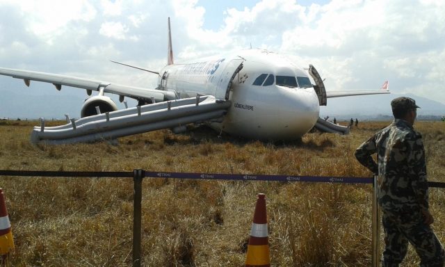
Hydraulic fluid leaked from the left landing gear. The inboard wing had “significant holes” and the right-hand inboard slat had been damaged by “multiple foreign objects”. The belly fairings on both sides of the fuselage were badly scraped.
The runway edge lights and the taxiway edge lights for the two taxiways were broken. The aircraft had also smashed through three signs citing the take-off distance remaining (1,281m, 1,770m and 2,242m).
Kathmandu’s airport fire watch tower was manned and they were theoretically watching approaching aircraft for any issues. But they couldn’t see the Airbus in the moving fog. They did hear it, though. It didn’t sound right. They alerted the fire crew and then contacted Kathmandu Tower.
At the same time, Katmandu Tower contacted the flight crew to ask if they had landed. Initially, there was no response. Then the flight crew requested medical and fire assistance at the end of the runway.
A few minutes later, they requested a bridge and stairs so they could open the door and let the passengers out.
Ten minutes after the hard landing, the aircraft was vacated using the evacuation slides. There were no injuries to passengers and crew.
There’s no reference at all to the database issue in the results of the accident investigation, although that’s what made headlines (especially in IT circles, and rightly so) when the report was released.
Instead, the report’s conclusion focused on the flight crew.
Causal Factor
The probable cause of this accident is the decision of the flight crew to continue approach and landing below the minima with inadequate visual reference and not to perform a missed approach in accordance with the published approach procedure.Contributory Factors
Other contributing factors of the accident are probable fixation of the flight crew to land at Kathmandu, and the deterioration of weather conditions that resulted in fog over the airport reducing the visibility below the required minima.
The investigation commission concluded that if the flight crew had been visual, they would have easily corrected for the offset runway threshold and so the accident would never have happened.
They were clearly not visual at MDA or MAP, whatever the Captain claimed. To counteract this bad decision, they kept the autopilot on much longer than standard, which meant that they continued to aim for a runway threshold which was in the wrong place. So I agree that although the wrong coordinates clearly played a part, the real cause was the continuing of an approach well beyond safe procedures.
However, this doesn’t really take into account that the pilots are the last line of defence. Yes, clearly bad flying and a disregard for basic safety are terrible things. And I hate to argue that they “could have got away with it” if circumstances had been better… because that is, of course, exactly the mindset that can cause this type of fixation on landing, the confidence that it’ll be good enough, that nothing else will go wrong. And 90% of the time, it’s probably true.
But at the same time, part of the point of aviation safety is to deal with human factors and, in this case, the margin for human error (whether you call it a mistake or bad flying) had been lost.
The report does deal with the other issues in the safety recommendations. It includes a long list of actions for the operator, including training their flight crew to follow Standard Operating Procedures and better verification of the navigational data on their flight management systems.
The Civil Aviation Authority of Nepal is called out for not checking their raw aeronautical information and better planning for airport works before sending out changes.
The weather’s role in this is also mentioned, as the MET Office didn’t include a SPECI (special weather report) regarding the visibility reduction and the Air Traffic Controllers did not tell the flight crew about the rapidly deteriorating conditions on the ground.
And finally, LIDO, who provided the charts with the updated database, were told to develop a more robust system which would include the NOTAM data for critical airport details.
Since the accident, Turkish Airlines requires a three-man crew for flights into Kathmandu and the minimum visibility for flying into the airport has been increased from 900 metres to 1,800 metres.
Neither of these would have stopped this accident from happening, unless a particularly competent second officer was willing to pipe up and insist on a go-around.
Turkish Airlines also stated that they are looking into better quality control of their charts and one hopes updating the training of their flight crew!
After the accident, on the 1st of April 2015, a new supplement was issued cancelling the January supplement completely.
The runway extension has still not happened.
NOTE: The accident report is no longer accessible where I originally found it, on the Nepalese Ministry of Culture, Tourism and Civil Aviation website but I did find an unlinked version of the PDF report in progress which looks to me to be the same file with a slightly different file name.


I (finally) retired from flying more than eight years ago and I am aware that a lot has changed, so I am a bit confuse on the terms used:
When I was still active, there was no such thing as am “DA” in a non-precision approach.
Whether or not using QFE or QNH on the altimeter setting, the “Decision height” was a point on a precision approach. On a cat one approach this would have been 200 feet above the threshold.
Making a non-precision approach, the pilot might have has to make a stepped descent until the final segment, when the lowest altitude would have been the MDA or minimum descent altitude.
It was permissible to continue a level flight until the MAP or missed approach point, when the approach no longer would have been deemed to have led to a safe landing and a missed approach would be intitiated.
In more recent days with more exact instrumentation the crew would calculate a continuous descent to a “VDP” or visual descent point, the minimum descent coinciding with the MDA (or MDH).
But I admit, I am out of the loop now.
And so the use of “DA” in a non-precision approach confuses me.
Still confused and, since I have not flown for more than eight years all I can do is go back to the basics, from the days when I started training for my instrument rating. And that must have been around 1971.I have forgotten a lot, too I suppose.
So what follows is “old hat” and may not be totally valid. Not only that, it makes the actions of the THY crew even more confusing in my mind.
There is confusion about heights and altitudes, too. In a non-precision approach the minima are not based on height above the threshold, but on the QNH or QFE related to the airport reference point.
Some operators use QFE though most nowadays prefer QNH. This requires a bit of mental arithmetic, but gives the crew a better overall picture of their relationship to the surrounding terrain.
The radio altimeter is used in Cat 2 and Cat 3 operations, it is not valid to determine minima even during a Cat 1, a company I worked for allowed it to be set to 500 ft only as a reminder.
Most pilots use Jeppesen, now widely available in CD-ROM or DVD.
Some airlines used to have their own airway manuals. BA had Aerad, KLM used it’s own system too but it was tailored to the KLM network and fleet, therefore not really useful for GA operators
There are various minima in use: MEA, MORA, MOCA, MDA, DA/DH.
But let us look at an old-fashioned single-beacon ADF approach. No radar, no VOR-DME.
Assuming the beacon might be perhaps 10 miles from the threshold.
Over the beacon, the crew would descend to a safe altitude, perhaps descend further in a holding pattern. At the altitude as prescribed in the approach chart (of course all assuming cleared by ATC), the aircraft would fly a QDR outbound, reporting “the beacon outbound” and descend further to a platform height whilst starting the stopwatch for a timing. Time up, the pilots would make a procedure turn and establish on a QDM, all the time of course going through the checklist.
Passing the beacon again, the gear would come down, timing started and the crew would report “the beacon inbound”.
The flight would now descend to the MDA. If no ground contact, it would be allowed to continue level flight AT the MDA. If, after a certain time, no or insufficient visual clues were available the non-flying pilot would (depending on the company procedures) announce: “Time is up, no contact, go around”).
Sometimes there would be a locator beacon closer to the runway. This made life somewhat easier, especially if the aircraft had two ADF units. The crew could fly a QDM and QDR (magnetic bearing to and from a beacon). Not seldom was there a minimum altitude to be maintained between the two beacons, descent to MDA not to be initiated until past the locator beacon.
Modern navigation systems allow for a straight line to be programmed. But the RNAV and FMS systems nowadays have nearly every airport in their database. So, as long as some form of VOR-DME, VLF-Omega or GPS is being received reliably, the crew can select an airport and the relevant STAR and SID as well. So, the crew will listen to the ATIS, or note the arrival information from ATC and select, let’s say, a “Sylvia one alpha arrival for runway 1R”. Connect the RNAV to the autopilot and it will bring the aircraft all the way to the approach point, following the STAR (Standard Arrival Route). Modern systems can even make the appropriate changes in altitude.as the A/P flies the STAR.
But no, trying to picture this approach in my mind and taking into account that this was a flight operated by a modern, major state airline, the story still makes no sense.
Had the airline a route clearance unit?
If so, did the crew make use of it?
If not, why not?
For such an experienced crew to let this happen: this still confuses me.
At least, there were no casualties.
Here’s the details of the approach:
Kathmandu Airport RNP AR APCH for RWY 02 chart includes the approach procedures for arriving aircrafts from west , south, and east sectors to RATAN Fix and then carry out the RNP AR APCH procedures as cleared by ATC to Initial Fix maintaining 8700 feet at KT 532 and continue to Final Approach Fix (APP) KT 530. Then commence the approach from KT 530(14.4 DME) with full landing configuration till Minimum Descend Altitude (MDA)/ Minimum Descend Height (MDH) to Missed Approach Point (MAP).
I don’t feel like this helps but in case… in the analysis of the final report, it says:
During the interview after the accident for post flight incident report the pilots stated that they were visual with the approach lights of the runway at the Decision Altitude and continued the approach below the DA. According to the PF, during the final approach he momentarily lost visual contact with the runway but before he initiated a missed approach the runway became visual again and he decided to land. However from the following it appears as though there is a high probability that the visibility requirements were below that needed to continue the approach to land.
When the “MINIMUM” auto-call out was annunciated at 01:58:30 hrs the PF responded “continue until 300 ft” which may imply that he was not visual with the approach lights at the decision altitude and wanted to continue below the decision altitude with the expectation of getting visual. Although the Captain stated in his report as well as in his statement that he was visual with the approach lights at decision altitude. Had he established visual contact with approach lights at decision altitude, the response to the “MINIMUM” auto-call out would have been “visual and continue” in accordance with SOP. The PM, whose duty is to look out of the cockpit for the approach lights and runway while the PF flies the approach on instruments, also did not call out “visual”.
Oh, and Rudi, I forgot to say! The ATIS was not working that day!
I’m … amazed … that the data is updated every 28 or 56 days; when I was training for and using an instrument rating (mid-1970’s), Jeppesen sent out chart changes weekly. I understand that getting data out frequently is tricky; my last software employer used to release updates to a large MCAD program every two weeks, which made life … interesting — but data is not as complicated as a compiled program. It also sounds like there has not been enough thought about making sure that all airports suitable for passengers are integrated into a single reporting system; is everybody thinking that’s Someone Else’s Problem?
Like Rudy, I am surprised and thankful there were no injuries, especially since the yawing course that took the plane off the runway shoulder might have rattled the passengers in directions a lap belt doesn’t protect against.
I was surprised by that as well. Based on the report, this is a standard cycle in the industry. Although it implies that other navigation systems did not have the error.
I know my attempts to figure out how this happened are based on knowledge and procedures that may be well and truly out of date by now. And technical advancements are coming fast and furious too.
Jeppesen indeed sent weekly revisions but they are based on information issued by the relevant authorities.
If these authorities fail to make these changes known then Jeppesen obviously cannot incorporate them in their revisions.
“Minimum” autocalls, in my days, were most definitely not permitted to be used to determine minima in a non-precision approach.
The rad alt readings are (were ?) only valid criteria to determine minima in cat 2 and cat 3 approaches where the relevant obstacles are charted and incorporated in the procedure for the purpose.
The last aircraft I flew were a variety of Citations, from the “classic” 500 to the 650 and also the Stallion, a converted and rebuilt 500 with Williams engines and glass cockpit. A very potent machine but privately owned. The last aircraft I flew on an AOC was the Fokker F27, probably a museum piece by now.
So no matter how I try to make sense of this incident, my related knowledge is too far out of date I guess.
So I am still confused.
What seems to stand out here to me is that these crews were also getting confused. It appears that whilst they were flying a highly advanced aircraft, used to a world in which normally the ground-based equipment also can be expected to be state-of-the-art, suddenly they were confronted with a situation where the airport and it’s navigation aids conform more to what pilots may have expected 30, 40 years ago. And they simply were not trained to cope with this technological mismatch. Could this possibly be the underlying cause?
It also seems that the crew failed to consult what in some airlines is know as the “route clearance unit”. This in its basic form is a database which pilots can use to familiarise themselves with the peculiarities of airports they have not, or not recently, flown into.
But I am only guessing here, it is well possible that the crew had been in receipt of a prior briefing on this airport.
Interesting read, but I didn’t understand this: “The Civil Aviation Authority of Nepal never considered the cycle of revisions and updates when they cancelled the AIP supplement using NOTAMS.”
I had to look up AIP, that’s “Aeronautical Information Publication”? Is the problem that NOTAMS are issued less frequently than AIPs?
Ken,
Th e AIP is the source of permanent information.
If some changes are made that are temprary or on short notice the civil aviation will issue a NOTAM, class I or II depending on the level of urgency.
If, for instance, an aircraft block a runway because of a failed undercarriage, a class one NOTAM will be issued by means of telecommunication.
If there is time to issue the NOTAM in printed form it will be class II and can be handed to the pilots as part of their pre-flight briefing.
Class II can be anything, like work in progress, temporary closure of a runway for maintenance, a navigational aid out of service.
Sometimes the airport will issue a “SNOWTAM” if heavy snow affects the airport or in times of bird migration a “BIRDTAM”.
That actually is a bit of liberty the format, NOTAM means “Notices to Airmen” (or, nowadays, “airwomen”), a bit like adding “-Gate” to any government scandal.
A class one NOTAM can if necessary be included in ATIS information and / or passed on to the crew by ATC.
NOTAMS are issued frequently and as a rule have a limited period of validity.