
TB-20 en route to Bilbao crashes into lost sheep
This story of a light aircraft crash in Northern Spain was one that I didn’t quite have space for in Why Planes Crash Case Files: 2003.
The date was the 27th of June in 2003. The aircraft was a Socata TB-20 Trinidad. The pilot was German, 58 years old and an experienced private pilot whose licence was first issued in 1969 and had been renewed in 2002. He had 1,420 hours flying time. The passenger was also German and the two were flying for pleasure, not business.
On that day, the pilot filed a flight plan from Madrid Cuatro Vientos Airport to Bilbao airport; a straight-forward flight of about 180 nautical miles.
We don’t know the details of the flight preparation or how well the pilot knew the route and the destination airport. Bilbao is more than a bit tricky. The runways are in a valley which is open to the sea at the west/northwest side and closed on the east/south-east side by hills. Mountain ranges enclose the valley to the northeast and the southwest, with peaks of up to 1,500 feet. About eight nautical miles south of the airport, there are a few more mountain peaks that need to be avoided, with heights of about 2,500 feet. Twenty nautical miles south of the airport is the Cantabrian mountain range, where the peaks reach over 4,000 feet (1,200 metres). So to fly into Bilbao from the south, the aircraft needs to descend over a fair amount of high ground before descending to sea level.
The Socata TB-20 Trinidad is a light, single-engine aircraft. It is a low-wing plane which can be laid out with four or five seats, with a retractable gear and a constant speed propeller. The TB-20 is a popular aircraft for training and touring. The letters TB stand for Tarbes, the French city where the aircraft is manufactured.
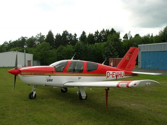
It’s a zippy little aircraft, capable of maintaining cruising speeds of over 180 knots with high power (and heavy fuel consumption). On the flight plan, the pilot estimated a flying time of one hour and thirty five minutes for the 180 nautical mile flight from Madrid Cuatro Vientos to Bilbao, based on a mean speed of about 114 knots.
There’s a few reasons why the pilot may have expected such a slow speed. Headwinds can cause major delays. Flying anywhere around Madrid means a high risk of rerouting and delays from air traffic control. Or possibly he decided to take the flight slow to save on fuel.
The endurance of the aircraft – that is, how long it can be expected to fly before the fuel runs out – was estimated at two hours and forty-five minutes, more than an hour over the the estimated flight time at a relatively low speed. This additional time would allow for deviations and diversions if needed.
That day, the pilot filed his flight plan and then departed Madrid Cuatro Vientos from runway 28 a few minutes early, at 11:09. The weather was good with clear skies around Madrid and to the north as far as the province of Burgos.
At the same time, though, clouds were gathering over the Cantabrian mountain range. A Spanish shepherd accompanied his flock of sheep on the southern slopes. The peaks of the mountains were shrouded in cloud.
The pilot of the TB-20 contacted Madrid Control and asked to fly direct to Burgos at a height of 6,500 feet. Madrid gave him a transponder code and confirmed his location on the TMA Madrid surveillance radars. There was no other traffic at that level and Madrid told the pilot that he could climb at will.
The skies still held few clouds as the aircraft flew over Navacerrada at 7,300 feet. The flight reached Burgos in less than an hour and continued directly north-north-east towards Bilbao, flying over La Bureba moors, Sierra de Oña and the Ebro valley. As they crossed the Aradén mountain top, entering the Cantabrian mountain range, the aircraft was about 40-50 nautical miles from Bilbao airport. At 7,300 feet, they were clear of the cloud and well above the high terrain of 4,000 feet.
Near the Angulo pass in the Cantabrian mountain range is the notification point AMTOS, which is twenty-two nautical miles from the Bilbao radio beacon (VOR).
The Cantabrian mountains were smothered in cloud. The Spanish shepherd accompanied his herd of sheep through the fog which covered the slopes of Sierra Salvada.
The TB-20 was about half an hour from Bilbao airport when it began its descent from 7,300 feet. The clouds continued to thicken as the light northwest winds pushed them into the Cantabrian mountains.
There are two visual routes into Bilbao from the south. One is to remain above the clouds until a little before Llodio and then descend through a gap in the clouds, as long as the clouds aren’t so high as to push the aircraft up into IFR traffic levels. The difficulty with this option is finding wide enough gaps to descend while keeping in sight of the ground.
The second route is to keep visual contact with the terrain, descending below the cloud front and maintaining 500 feet above the ground and below the clouds, entering the controlled airspace at Llodio.
But the clouds hung low over the mountains (and the sheep), between 2,500 feet and 3,500 feet above sea level. A pilot familiar with the terrain might be able to navigate through the Angulo pass to the west or the Orduña mountain pass to the east, where the elevation dropped to 2,700 feet, if the clouds remained up at 3,500 feet. There’s no question that this route would be dangerous and ill-advised for a foreign pilot just passing through. The pilot’s only real option was to wait until Llodio and then descend through a gap to keep visual.
These two routes have one thing in common: they avoid a pilot under Visual Flight Rules becoming lost in the cloud while crossing a mountain range.
| 12:11:40 | D-EKBI | Bilbao approach, this is Delta Echo… |
| 12:11:46 | Bilbao Approach | Station calling, say full call sign again. Please. |
| 12:11:50 | D-EKBI | It is, this is Delta Echo Kilo Bravo India. |
| 12:11:56 | Bilbao Approach | Delta, Echo Kilo Bravo India muy buenas, Bilbao Approach, go ahead. |
| 12:11:59 | D-EKBI | VFR flight from Cuatro Vientos to your field. Twenty miles from your field, descending to four thousand feet,… IFR(?) |
The aircraft contacted Bilbao Approach, reporting that it was 20 miles from the airport and descending to 4,000 feet.
But Bilbao ATC never received the flight plan with the pilot had filed at Madrid. As a result, the controller did not know that Bilbao was the pilot’s destination and believed that the aircraft probably just wanted to fly over the airfield. The controller activated a flight plan on behalf of the flight.
At the time of this first contact, Bilbao’s radar showed the aircraft south of the AMTOS checkpoint, 37 miles from Bilbao instead of the 20 miles that the pilot reported. However, pilot notifications override surveillance radar supplementary information, so the controller presumed that the aircraft was 20 miles out, not 37.
Still it might have been nice if he’d mentioned the discrepancy.
| 12:12:15 | Bilbao Approach | Delta Echo Kilo Bravo India squawk three four five six, confirm squawk three four five six? |
| 12:12:23 | D-EKBI | Squawking three four five six, that is correct |
| 12:12:27 | Bilbao Approach | Delta Echo Kilo Bravo India roger. Runway in use in Bilbao is three zero, wind three zero zero, ten knots, QNH one zero, two zero. And for your information there are several arrivals, approach for runway three zero. |
| 12:12:44 | D-EKBI | … three zero and the… |
| 12:12:53 | Bilbao Approach | Delta Echo Kilo Bravo India do you prefer to hold south of the field or descend down to two thousand feet. |
The Approach controller had difficulty understanding the pilot and wasn’t sure what the pilot intended: was he coming into Bilbao to land or was he crossing Bilbao’s terminal manoeuvring area (TMA) to continue to another destination?
If the pilot was inbound to Bilbao, the controller expected him to remain above the clouds as he passed over the mountains and then descend through a gap at the southern entry point of Bilbao’s zone. If the pilot was planning to cross the TMA, then the aircraft would need to descend to 2,000 feet so as not to affect the traffic on approach.
| 12:13:02 | D-EKBI | To the south of the field descending to 2,000 ft |
Knowing the weather conditions, the controller tried to confirm that the pilot had sight of the terrain. However, he said that the transmissions from the pilot were practically inaudible.
| 12:13:07 | Bilbao Approach | Delta Bravo India are you in contact with the terrain? |
| 12:13:14 | D-EKBI | Not by the moment… But hold… overhead… |
| 12:13:18 | Bilbao Approach | Delta Bravo India say again, please. |
| 12:13:21 | D-EKBI | … not ground contact by the moment… descend over Bilbao… |
The pilot appears to have believed that he received an instruction to descend to 2,000 feet for his approach to the airfield. Further, it’s quite clear that he wasn’t able to see the ground. The controller was clearly struggling to understand what was happening.
| 12:13:33 | Bilbao Approach | Delta Bravo India do you confirm proceding to San Sebastian? |
| 12:13:47 | D-EKBI | … we are looking for a pass to descend to two thousand. |
If by “pass” he meant a gap between the clouds for his descent, then that would mean he was unaware of his position: at 20 nauticaul miles from Bilbao, he would not yet flown over the mountains. However, it may be that he believed he was only 10 nautical miles away.
If he was looking for a pass between the mountains, then he was going the wrong way. He was heading straight for the highest elevation area between the Angulo and Orduña mountain passes.
| 12:13:55 | Bilbao Approach | Delta Bravo India do you confirm your intentions? |
| 12:14:04 | D-EKBI | [inaudible] |
The controller received no further response from the pilot. The aircraft was still visible on his radar as it descended from 5,900 feet to 4,800 feet at 660 feet/minute; a normal descent rate for that aircraft in normal conditions.
But conditions were not normal.
The controller asked an Iberian flight to please try to relay a message.
| 12:23:38 | Bilbao Approach | Delta Bravo India, Bilbao. |
| 12:23:52 | Bilbao Approach | Delta Bravo India? Bilbao. |
| 12:25:37 | IBE 1455 | Bilbao, buenas tardes, Iberia uno cuatro cinco cinco, librando… (Bilbao, good afternoon, Iberia one four five five, climbing…) |
| 12:25:46 | Bilbao Approach | Iberia uno cuatro cinco cinco, muy buenas, continúe ascenso… (Iberia one four five five, good afternoon, continue ascent…) |
| 12:25:50 | IBE 1455 | Ascenso… (Ascent) |
| 12:27:08 | Bilbao Approach | Iberia uno cuatro cinco cinco, Bilbao (Iberia one four five five, Bilbao). |
| 12:27:12 | IBE 1455 | Adelante para Iberia uno cuatro cinco cinco (Go ahead for Iberia one four five five). |
| 12:27:14 | Bilbao Approach | Uno cuatro cinco cinco sí, podría hacer de relay para Delta Echo Kilo Bravo India simplemente llamarle, a ver si le recibe (One four five five yes, could you relay for Delta Echo Kilo Bravo India to see if he receives you). |
| 12:27:31 | IBE 1455 | Delta Echo Kilo Bravo India from Iberia one four five five. |
The controller phoned Madrid control to see if they had heard from the pilot. He explained the situation: difficult to hear – it appears and disappears in the radar – very low – now I can’t see it – there is quite a lot of cloud – unintelligible – no reply.
Madrid confirmed that they had not heard from the aircraft and further that they did not have a flight plan for it, despite the fact that the pilot had filed a flight plan before he departed and Bilbao had activated a flight plan when the pilot first made contact.
Two hours and forty five minutes after the aircraft had departed Madrid Cuatros Vientos Airport, the Search and Rescue team began to search for any sign of the aircraft or its emergency beacon. By now, the TB-20 would be out of fuel. One of the searching aircraft picked up a signal from the emergency beacon in the mountains but the clouds and mist were so thick, the searchers could not see the aircraft or if there were any survivors. An intensive search of the area on foot was initiated but they were unable to find any trace of the wreckage and at sunset the search was suspended.
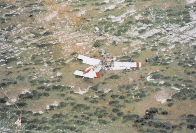
The next morning, the weather had cleared. The first person to arrive at the crash site was the shepherd, who had lost one of his sheep. He returned to the mountain slope to look for it. There, he found the sheep, dead, a few metres away from the aircraft wreckage. The left wing had struck the sheep as the TB-20 crashed into the mountain.
The aircraft had initially impacted the ground with its belly, tearing off the nose assembly doors. The wings were level and the propeller turning as the aircraft attempted to fly upwards parallel to the mountain slope. The aircraft continued to climb for another 18 metres up the mountain slope with parts breaking off at both sides as it bounced and churned up the ground. The left wing struck the sheep, killing it instantly.
Then the aircraft crashed into a rock jutting out from the terrain. The wings were pulled off of the fuselage and the cabin disintegrated. The engine, propeller and instrument panels were thrown forward 10 metres (30 feet). The stand-by compass was found 40 metres (130 feet) beyond the main wreckage. The bodies of the two occupants were also thrown out from the cockpit and were found 7 and 17 metres (22 and 55 feet) away.
In hindsight, it seems clear that when the pilot announced that he was 20 miles south of Bilbao, he was actually 37 miles south. He was travelling faster than he had planned in his flight plan — in fact in the final stage of the flight, he was travelling at 169 knots and descending at 660 feet per minute, a speed which gave him very little reaction time. Although the pilot no doubt knew that there was a 4,000 feet mountain range and then further a few 2,500 feet peaks that he needed to overfly before reaching Bilbao, when the clouds closed in, he decided to continue with his flight and worse, to descend. In his conversation with the Bilbao controller, he made it clear that he did not have visual contract with the ground, he wasn’t sure where or how to descend into Bilbao and he was anxious to find a pass.
The controller struggled to understand the pilot. The combination of bad communications and dealing with commercial traffic may have contributed to the fact that he didn’t directly ask the pilot his intentions from the start but instead gave the pilot what was quite frankly a confusing choice. If the controller had seen the flight plan, of course, he could have skipped this communication and he might have dealt with the pilot’s location and descent into cloud more decisively. As it was, both the controller and the pilot were under a heavy workload.
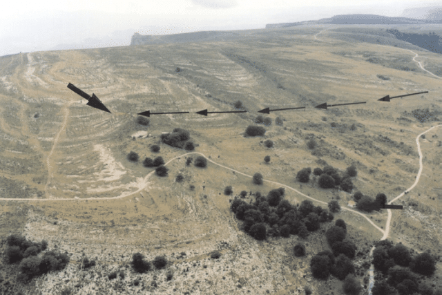
After the aircraft disappeared from radar, it continued to descend for another 1,000 feet. The pilot must have seen the terrain at the last minute, as the wings were level and the aircraft was pitched almost parallel to the mountain slope. It was too late. The aircraft must have been travelling at high speed to drag itself across the terrain for almost 47 metres before crashing against the rock jutting out from the mountain slope. The low visibility, the high speed and the steep descent meant that the pilot didn’t quite see the mountain in time to climb over it.
From the accident report:
Causes
The main cause of the accident was the lack of visibility and the IMC conditions when the VFR flight entered an area of clouds over high mountain terrain. It lost contact with the ground and continued its descent at high speed. Possibly the pilot was not familiar with the surroundings and was not carrying out careful, observed navigation.Various circumstances coincided at the scene of the accident, such as deficient communications and lack of knowledge on the part of the Bilbao approach control center (APP Bilbao) of the imminent arrival of the aircraft at TMA Bilbao. There was no communication from the aircraft reporting its earlier arrival at Bilbao with respect to its estimated time in the flight plan.
The key here is that a visual pilot descended into cloud, which is always dangerous. He may have felt confident that he would not lose orientation by relying on the autopilot but, with high ground to the north of Bilbao, the flight would have been dangerous even if he had known where he was. The fact that he was out by 17 miles – or possibly out by as much as 27 miles considering his comment of looking for a pass – meant he never had a chance.
And don’t ask me why, but I can’t help but feel a bit sad for that poor sheep as well. Wet, cold, lost and alone, the last thing it could have expected was to have a aircraft crash into it from nowhere.
For eleven more accidents from 2003, pick up a copy of Why Planes Crash Case Files: 2003 from an e-book store near you. I think you’ll like it and every sale helps to support the website!


