
Airbus Flying Too Close To The Ground
On the 23rd of May 2022, an Airbus A320, registration 9H-EMU, departed Stockholm Arlanda airport bound for Paris-Charles de Gaulle airport as flight NSZ 4311. There were six crew and 172 passengers on board. The captain was the Pilot Flying and the first officer was the Pilot Monitoring.
The initial flight was uneventful. The flight crew correctly anticipated a landing on runway 27R. They listened to the pre-recorded airport information (ATIS information Quebec):
transition level 70, wind 280° at 10 kt, visibility 10 km, broken clouds at 1,500 ft, few cumulonimbus (CB) at 5,000 ft, temperature 19 °C, dew point 14 °C, QNH 1001.
The QNH is the pressure setting on the altimeter, which the airfield derives by using the measured atmospheric pressure at the ground. On approach, the flight crew dial in the correct QNH, in this case 1001, so that their altimeter will show them their altitude above sea level for their destination for the current conditions.
The weather was worsening as they approached, with multiple layers of cloud and rain. The ILS (Instrument Landing System) for runway 27R was out of service, so the flight crew prepared for an RNP approach with LNAV/VNAV (Lateral Navigation/Vertical Navigation). This is a type of GNSS approach, the Global Navigation Satellite System, which in the EU is provided by GALILEO, the European Satellite Navigation system which complements the US Global Positioning System (GPS).
For this LNAV/VNAV approach, the lateral guidance is mainly based on GNSS positioning; however, the vertical guidance is based on the aircraft’s barometric altitude and as such, is affected by altimeter setting errors. This is in contrast to vertical guidance satellite-based approaches which use GNS positioning and augmentation systems and thus are not sensitive to QNH errors. The aircraft did not have the equipment required for satellite-based vertical guidance.
The Airbus A320 descended through heavy rain with moderate turbulence; the flight crew kept the wipers on at high speed. There was nothing to see except the grey clouds.
Norwegian Air UK uses “Red Nose” as a call sign to distinguish them from Norwegian Air, a reference to the bright red front of the aircraft. This call sign has confused at least a few controllers at JFK:
To be fair, that was a few years ago. As the flight approached Paris, they spoke to an Intermediate (ITM) Controller (Arrivals) who was already familiar with the call sign.
Controller: Red Nose four three one one, descend… Descend 6,000 feet, one zero one one.
NSZ4311: Six thousand feet, one zero one one… one… zero one one. Red Nose 4311.
A few minutes later, she called them back.
Controller: Red Nose 4311, descend 5,000 feet, one zero one one, cleared full RNP 27 Right.
NSZ4311: Descend 5,000 feet, QNH one zero one one, cleared full RNP approach, 27 Right, Red Nose 4311.
The observant among you will have noticed that the ATIS gave a QNH of 1001 while the controller consistently said 1011. The controller was wrong. The first officer’s first stuttered repetition was likely as he dialed in the new pressure setting to the altimeter.
If they’d written down the QNH from the ATIS and then checked the pressure setting given to them by the controller, they may have noticed the discrepancy.
The controller then spoke to an EasyJet flight which was also on approach.
Controller: Easy75MikeAlpha direct Papa Golf six five zero… and descend 5,000 ft one zero one one, cleared RNP approach Two Seven Right.
EasyJet: “Direct to Papa Golf six five zero descent 5,000 ft QNH one zero zero one Easy75Victor Alpha.
EasyJet did not repeat the QNH that she gave but instead gave the correct QNH as per the ATIS. The controller appears not to have noticed.
Her next call was to an Air France crew. The controller addressed them in French and used the correct QNH: 1001. The Air France crew read back the call with the correct QNH.
Meanwhile, the flight crew in the Airbus A320 had reached the approach point where they could begin their final descent. They were 14.3 nautical miles from the runway threshold with an indicated altitude of 4,889 feet on the pressure setting of 1011.
Under the correct QNH of 1001, the altimeter would have shown them that they were 4,623 feet above mean sea level. As a result of the wrong QNH, their altimeter showed them as consistently 280 feet higher than they actually were.
The Intermediate Controller asked them to change frequencies to speak to North Tower.

The flight crew continued their descent, conducting altitude-distance checks at every mile during the approach. Unfortunately, the altitude-distance checks rely on the altimeter altitude, and thus did nothing to highlight that the altimeter altitude was wrong. .
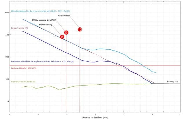
There was another opportunity to spot the error. The aircraft’s radio altimeter only works over a short range, but it shows the exact height above the terrain, because it derives its information by reflecting radio waves off the ground.
As the Airbus descended through 2,500 feet, the talking radio altimeter kicked in with an automatic call out of their height above the ground. From this point on, the radio altimeter data was displayed on the primary flight displays for both pilots. The Pilot Monitoring should have been monitoring it as a part of his instrument scan for the remainder of the approach.
North Tower: Bonjour Red Nose 4311, you are number one, wind two six zero degrees, 12 knots, runway two seven right, cleared to land.
The crew read back the clearance and continued, still flying through cloud. At 3.1 nautical miles from the runway threshold, their altimeter showed them at 1,392 feet (actually 1,123 feet amsl and 837 feet above the ground). They were travelling at 139 knots indicated airspeed and descending at 738 feet per minute. They were fully configured for landing and believed themselves to be in a stabilised approach, so they continued.
In the control tower, the Minimum Safe Altitude Warning (MSAW), a ground-based safety system, triggered as the aircraft reached 1.53 nautical miles from the runway threshold at just two hundred feet above the ground. The controllers could not see the aircraft: the visibility east of the airport was worse than at the runway because of the low clouds and rain.
This warning is meant to alert controllers that an aircraft’s descent rate/profile is putting the aircraft at risk of a collision with terrain. When triggered, an amber display [MSAW] flashes and an aural warning sounds for all controllers. The controller monitoring the aircraft should deactivate the warning and immediately advise the crew that a terrain alert was generated and instruct them to urgently check their flight level and altitude, while giving them the QNH.
Nine seconds passed.
The decision altitude for the crew was 50 feet over the published minima for the RNP approach, so in this case, 752 feet plus 50. At the point when their altimeter showed that they had reached their decision altitude of 802 feet, the flight was actually at 537 feet above sea level and 122 feet above the ground.
Just as the captain decided to break off the approach, the controller finally spoke up.
North Tower: Red Nose 4311, I just had a ground proximity alert, are you OK? Do you see the runway?
The flight crew did not respond. In the tower, the Minimum Safe Altitude Warning was triggered again.
At one nautical mile from the runway threshold, with their altimeters showing 735 feet (actually 461 feet amsl and 52 feet above the ground), the captain disengaged the auto pilot and pitched up.
As the captain moved the thrust levers forward for the go around, their indicated altitude showed 679 feet, with the correct altitude being 405 feet.
The radio altimeter showed that they were just six feet above the ground.
There were no terrain warnings in the cockpit. The flight crew heard the talking radio altimeter call outs at 2,500 feet and at 1,000 feet but not any others. It has not been established whether those call outs actually occurred.
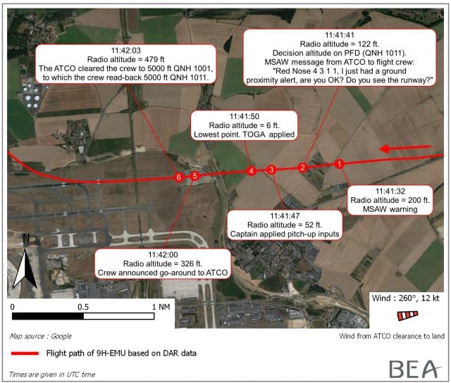
Amazingly, the go-around was just in time, within seconds of the Airbus A320 crashing into the ground almost a mile short of the runway. Once the aircraft was climbing, they called the air traffic controller to confirm that they were going around.
The controller saw the aircraft coming up out of the clouds.
North Tower: Roger Red Nose 4311, turn right on heading three six zero and climb altitude 5,000 feet, one zero zero one.
NSZ4311: Three six zero and climb 5,000 feet on one zero one one, Red Nose 4311
There has been some fuss that the problem on this day was caused by the fact that Paris-Charles de Gaulle runs air traffic control in both English and French. A number of English speakers are vehement that this is unreasonable and that this issue could have been avoided if only the crew had overheard the correct QNH given to the Air France flight at the very beginning. I’d like to highlight this exchange here: they did not recognise the correct QNH when spoken directly to them, let alone as a part of information spoken to another flight.
Much more relevant:
- ATC did not tell the flight crew to check their altitude and QNH, despite two Minimum Safe Altitude Warnings
- ATC did not notice the incorrect callback
Neither of those points have anything to do with the fact that the controllers are bilingual.
There was another issue.
Each set of parallel runways at Paris-Charles de Gaulle has two controllers: the controller and the controller assistant.
The assistant to the South Tower controller pointed out to the North Tower controller’s assistant that they had not turned the approach lights on.
The flight crew re-engaged the autopilot as they appeared to reach 1,203 feet but their pressure setting was still incorrect: they were actually 930 feet amsl and 593 feet above the ground.
The North Tower controller turned on the approach lights, after which he was relieved by his assistant and a new assistant was assigned.
The new North Tower controller gave the flight radar vectors. As they reached the downwind leg, he asked them to contact the ITM controller for the second approach.
The crew contacted North Tower again who cleared the flight for landing. The crew read back the clearance and asked if the approach lights were on. The controller confirmed that they were now on.
At no point during these interactions was the the QNH given or repeated to the crew or to any other flight on the same frequency.
Again, the Airbus A320 descended using the wrong pressure setting, believing themselves to be almost 300 feet higher than they were.
Again, a Minimum Safe Altitude Warning was triggered in the tower as they descended below the descent profile.
North Tower: Red Nose 4311, I just got a … a terrain alert, are you OK?
NSZ4311: Red Nose 4311, we are established on path and we have visual now.
The flight crew said later that they had no idea why ATC kept asking if they were OK.
At 2.54 nautical miles from the runway, with an indicated altitude of 1,227 feet (actually 954 feet amsl and the radio altimeter showing 572 feet above the ground), the Pilot Flying moved his sidestick nose up. At the same time, the autopilot disconnected. A few seconds later, the flight directors were switched off.
This time, they could see the runway well above the minima. Recalling the approach later, they believed that the PAPI lights, an aid which shows whether the aircraft is on the correct glide slope, showed “one white, one pink and two reds. Maybe three reds but not four.” If they had been at the correct height in the descent, they would have seen two whites and two reds, with the lights turning red to signify that the aircraft is too low.
The Pilot Flying corrected the flight path visually. Now that they had the runway in sight, the Pilot Flying was able to disregard the wrong altitude information and correct their descent.
The Airbus A320 landed safely. The flight crew still had no idea they’d come within six feet of crashing into terrain.
The preliminary report is on the BEA site: Serious incident to the AIRBUS A320
Incorrect QNH information, RNP approach with LNAV/VNAV minima conducted below the descent profile, near CFIT, go-around performed at low height before the runway without visual references, second approach performed below descent profile
The report gives the following points as deserving of particular attention for the investigation:
– non-activation of TAWS alert,
– triggering of radio-altimeter auto-callouts in the aircraft,
– settings and configuration of MSAW at CDG,
– MSAW phraseology,
– flight crew and air traffic controller training and procedures,
– flight crew and air traffic controller performance,
– additional ground and onboard systems to prevent CFIT during approaches using the
baro-VNAV function,
– safety impact assessments associated with the ICAO Performance Based Navigation (PBN)
plan and its regional and national adaptations,
– similar events,
– manufacturers operational documentation regarding approaches using the baro-VNAV
function.
The BEA has already come to a few conclusions, specifically that neither the controllers nor the flight crew seemed to understand the importance of QNH for a baro-VNAV function. In fact, the operational documentation covers the risk of the cockpit altimeters having different settings but does not ever touch on the risk of having the same incorrect pressure setting on both altimeters.
Although the pilots understood that they needed to conduct altitude-distance checks, at no point in the procedure are they asked to cross-check the QNH against the ATIS or with ATC.
Similarly, the Minimum Safe Altitude Warning is specifically there as a safety net for this type of situation. This failed because the controllers didn’t follow the phraseology and never recommended that the flight crew check their altitude or confirm that they were on the correct QNH.
The report includes a number of obvious recommendations for flight crew and Air Traffic Control to cover these failings of risk awareness and operational procedures.


Do we know why TAWS didn’t trigger? Surely it would be tied into the radio altimeter?
I expect there’s a rule in the system somewhere that it’s ok for the aircraft to fly into terrain when it’s configured for landing and on the glide slope. That’s how landings normally go.
Should the PM have said something like “please confirm QNH 1011” when they reset the altimeter?
I’d have thought that the radio altimeter showing much less than the expected altitude would have meant it would still trigger (to catch exactly this scenario) but obviously not…
The TAWS system in most (all?) aircraft that have it is GPWS – Ground Proximity Warning System [¹]. It does indeed allow the aircraft to go lower when configured for landing. However, most large transport aircraft these days, I think, have EGPWS (Enhanced GPWS [²]) which takes the GNSS/GPS position into account as well so should only allow the radio altimeter to get this low when much closer to the runway.
Dunno, wild speculation, etc, but maybe in this case it didn’t have a valid GPS position for some reason hence was working as an old-fashioned GPWS.
[¹] https://en.wikipedia.org/wiki/Ground_proximity_warning_system
[²] Not “Extended”.
How many assorted alerts does modern ATC have to deal with? (Not just MSAW but anything else that goes off in response to conditions.) One of the problems of modern medicine is the number of audible signals coming out of the average patient’s room; is ATC in a similar situation? If not, perhaps the controllers need a refresher on how urgent MSAW is.
Insane story, very well written Sylvia, thank you, this was a very dramatic tale for me. What a cluster-frack. They’re darned lucky to be alive. I am repeatedly amazed by your stories Sylvia, that computers and hardware aren’t monitoring more aspects of flight and when inconsistencies are found both the tower and pilots are alerted, and a pilot is forced to run through a checklist to verify everything.
I’ve done a bit of programming, most of the problems you’ve written about do not sound challenging to me. I can’t understand why this sort of hardware/software monitoring hasn’t been done years ago. Takeoff mode, typical flight mode, flight emergency mode, landing mode, all of these could have procedures that take location, conditions, and specific type of aircraft into account. The software that is used in self-driving cars is impressive, they are constantly refining driving including obstacle avoidance, stopping, parallel parking, roundabout navigation, etc. If they can make self driving car software that performs well, they can certainly write software to monitor every available input and alert pilots when there are problems. I am amazed that this wasn’t being worked on decades ago, along with the autopilot. Can anyone here tell me why this wasn’t don, and isn’t being done now?
Well, actually, they can’t. There was a Tesla that just plowed into the back of a semi here in Florida, killing both people. That’s the 37th such incident involving a fatality and self-driving investigated by the NHTSA this year, and it’s only July.
Software is hard. The reason it’s hard is because you must clearly and unambiguously
state what you want to have happen. Irreducible complexity is irreducible.
As Mendel wrote, you’re expected to fly into the ground when landing, but I don’t see why the radar altimeter didn’t throw some sort of fit.
Mike — I’ve done a LOT of programming (20 years as a formal software engineer, decades before that noodling around with computers). If anything, Gene is understating the difficulty of mission-critical programming; I spent a large part of my career coping with cases people hadn’t thought of(when they wrote the original code (or worse, cases management hadn’t thought of when they spec’d the code). One of the hardest things to do is dealing with conflicting inputs; e.g., if there had been software connecting the angle-of-attack indicator and other instruments on the 737-MAX, which should have been believed? Correlating results of pressure and radar altimeters is even trickier because the ground varies in height; they’d both have to communicate with a GPS and a detailed database to know whether the two reported altitudes were correct for where they were at a given moment. I suspect that it would be easier to develop ground stations that reported pressure automatically and altimeters with a receiver to pick up this information (and decide which of multiple signals to follow), but even that is non-trivial.
Extending my comment: Gene, the obvious reason the radar altimeter didn’t throw a fit is that it didn’t have the database I described above, and was wired (as Mendel suggests) not to go off when the plane was in landing mode; an alarm going off just as the plane is starting to flare for touchdown is NOT helpful.