The Navigator
I’m thrilled to be able to bring you a special post today. Captain Richard Otis sent this to me after I begged him to write down one of his many, many great stories so that I could share them with you. I hope you enjoy it as much as I have.
Captain Richard A. Otis, USN, spent thirty-five years in the US Navy Fleet and the Navy Air Systems Command, first as a Naval Flight Officer and later as an Aeronautical Engineering Duty Officer. The switch in positions was completely totally unrelated to the incident described in this blog post.
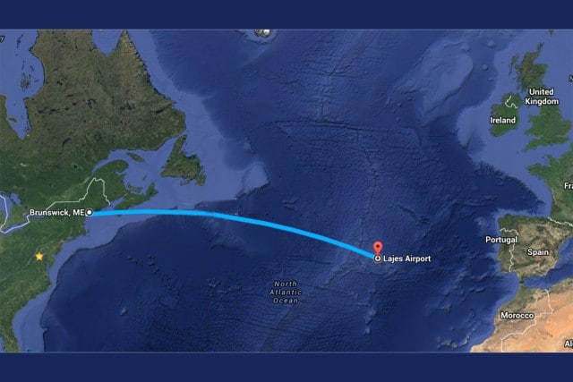
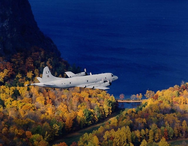
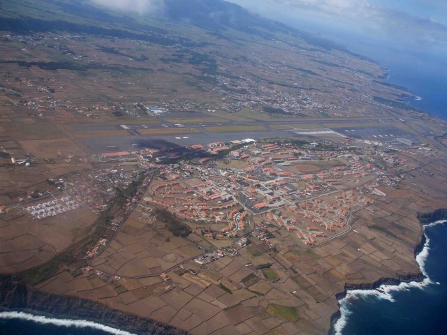
One winter back in 1974 my squadron, Patrol Squadron Twenty-Six, was flying out of NAS Brunswick Maine (KNHZ). One night, in the middle of a post-Christmas snowstorm, my crew was tasked to ferry one of our planes – a P3B-Orion Anti-submarine Warfare aircraft – from our home base 2,226 miles to our deployed site – the Lajes Air Base (LPLA), in the Azores.
The Azores is a small island chain belonging to Portugal located about 2/3 of the way across the Atlantic Ocean. At an airspeed of 250 knots, it takes about 8 hours to fly to, and it’s a pretty small target to hit. As the flight navigator, my job was to get the pilot “across the Pond” to the island base without getting lost.
The P-3B had several navigational systems to assist me: an early design inertial system, the LTN-42; an Attitude Heading Reference Systems (AHRS); a Doppler Airmass radar; the LORAN A, or LOng RAnge Navigation system; and a sextant – the tool of navigators since the eighteenth century.
The LTN-42 was a completely self-contained system comprising gyros and accelerometers. On a really good day, after an 8-hour flight, if it was within 10 or 15 miles, that was a good system! On a really bad day, it was totally worthless.
The AHRS was basically a computer using a magnetic compass heading and calculating a ground track by taking the aircraft’s true airspeed and magnetic heading, and applying a wind correction to calculate a ground-track. The problem with this system was determining the windspeed and direction. At low altitude – below 5,000 feet – this information was provided by a Doppler radar system pointed at the water. Above 5,000 feet, the Doppler radar was… let’s call it “ineffective.”
The navigator had to manually enter the forecast windspeed, such as it was. In older P-3A aircraft – but now removed – there was a drift meter, an optical device looking down through the floor at the ocean below. Assuming there were waves the Navigator could see, he could measure the aircraft’s drift angle.
The LORAN A receiver measured low-frequency radio waves from two or more ground sites. By measuring the time delay between the two stations, the navigator could plot a hyperbolic arc on a special chart. The aircraft was somewhere on this arc. Plotting multiple stations (assuming you could see them on the receiver – a function of radio propagation) he could plot an intersection of two or more arcs, which gave a accurate fix.
And of course, the final option was the sextant, which was very accurate… if you could see the stars.
My task was to get the pilots close enough to the Lajes island chain that they could pick it up on radar and/or the TACAN receiver. Both of these systems are line-of-sight limited, which is equal to 1.2xAltitude2 or about 190 nautical miles at 25,000 ft.
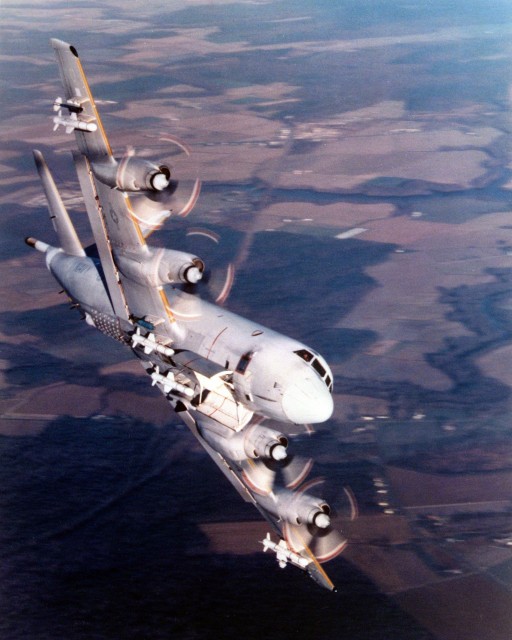
We took off shortly after midnight, heading east into the snowstorm. I plotted out the route on a World Aeronautical Chart, showing the great circle route between Brunswick and Lajes. Leaving the shoreline, the pilots told me that I had the navigation – which meant they’d already lost the TACAN signal from our home base.
I remembered from school that “East is least and West is best from True to Mag.” What that means is I had to add the west magnetic variation (10 degrees) to my desired true course (087 degrees). I gave the pilots the resulting magnetic heading of 097 degrees. I then checked my redundant navigation systems, which were all tracking nicely along my desired course.
The flight to Lajes is a bit over seven hours. Two hours into the transit, everything looked just fine and I went to the galley in the back of the cabin to get some coffee and chat with the crew. These days, the Navy allows men and women in all positions, including – recently – combat positions, but in the 70’s, flight crews were all men. In the early 90s, the P-3 was the first Naval aircraft that allowed mixed gender flight crews.
Moments later, the pilots announced over the Internal Communication Systems (ICS) that the LTN-42 had “dumped” – meaning, the gyros had failed and it was no longer providing guidance.
With my coffee in hand, I hurried back to my NAV station to check our position. Now you have to understand that Navy coffee comes in one flavor – very strong and black. It’s a sin to wash out your coffee cup or the coffee pot with anything but more coffee. So Navigator fatigue was not an issue at this point in time.
I found the AHRS giving accurate headings to the pilots and I told them both to switch to AHRS as a heading source (normally one is on the LTN-42 and one is on the AHRS for redundancy).
Unfortunately, at this time, we were at 25,000 feet with a hellacious crosswind of unknown strength and a true airspeed of 250 knots. Without knowing exactly the winds at altitude, I could only guess at our position along our planned course.
When we took off, I pleased to see our LORAN A system was giving me beautiful, large, primary sine wave from both ground stations, in addition to the smaller skywaves that are not useful for navigation. Lining the two ground waveforms together gave me that hyperbolic arc I mentioned earlier. At this point, I switched over to the LORAN A receiver, expecting its beautiful ground wave to serve as our backup. To my chagrin, the ground wave signal had vanished. This was not totally unexpected, as we were in the middle of the Atlantic Ocean, however it was rather unfortunate timing.
At this point, a Navigator usually falls back on celestial navigation. However, that requires you to be able to see the stars, which were still hidden by high clouds. My last resort was dead-reckoning (DR) navigation. Normally, this is good enough. But under these conditions, where I had a strong and unknown crosswind, and headwind – or tailwind? I didn’t really know! – DR navigation is spotty at best. Still, I gave it my best shot, based on my presumed winds aloft. I mean, after all, I just needed to get them within line-of-sight of the island, which is about 140 miles on the radar or a little bit further (say 180 miles) on a good TACAN receiver.
I had the radar operator searching diligently for the island chain, but as my estimated time of arrival approached and passed, he was still finding nothing but waves. At this point, I started to get a little concerned, but not half as concerned as the pilots.
The first pilot or “1P” – the pilot in charge – asked me to call our flight following stations, McDill Air Force Base, on the High Frequency Radio to ask for assistance. The conversation went something like this:
| 6PTN (me) | McDill, McDill, this is Six-Papa-Tango-November, requesting assistance. |
| McDill | Six-Papa-Tango-November, what assistance do you require? |
| 6PTN | We’re approximately 150 miles west of Lajes and we’re having some navigational difficulties. |
| McDill | Roger, standby. |
| … | |
| McDill | Six-Papa-Tango-November, call Skyking on 243.0 MHz. |
| 6PTN | McDill, we’re in the middle of the Atlantic Ocean and not in line-of-sight of anywhere. |
| McDill | Roger, understood. Call Skyking on 243.0 MHz. |
| 6PTN | Skyking, Skyking, Skyking, this is Six-Papa-Tango-November. Over. |
| Skyking | Six-Papa-Tango-November, this is Skyking. Lajes is at your 157 degree radial at 213 miles. Out. |
At this point, several thoughts were running through my mind. Who the heck was Skyking? How the heck did they know where we were? There were only a couple of possibilities.
First guess: it was a Coast Guard cutter, at the mid-Atlantic ocean station. The Coast Guard maintained a 300ft cutter on-station in the Mid-Atlantic to assist commercial air traffic. They were also the reason I decided not to join the Coast Guard. But I wasn’t anywhere near the mid-ocean point, so this explanation seemed unlikely.
Second: the military maintained a long range, distant early-warning network, which was designed to detected inbound enemy bombers in the event of war or surprise attack. But this was basically a coastal defense, and we were in the middle of the Atlantic Ocean.
My third – and best – guess was the TACAMO guys. TACAMO stands for “Take Charge and Move Out” and was the slogan for two squadrons flying the C-130 aircraft that provided strategic and covert long-range communications for our submarine fleet. They would know exactly where they were but they would be very reluctant to reveal their position to anyone else.
Trusting that someone knew what they were doing, I relayed the mysterious Skyking directions to my flight crew.
Ten minutes later, the radar operator called contact on the island. A few minutes after that, the TACAN locked on. Thirty minutes later we were wheels down in Lajes.
Several years later, I had a call from the Patuxent Naval Flying Club asking me if I’d like some free flight time. They needed me to fly the club’s Cessna 182 to Long Island to pick up some avionics gear for TACAMO. Not one to turn down free flight time, I immediately did a pre-flight on the Cessna and headed off for Long Island.
Upon landing, a large truck pulled up and started unloading several large crates of gear. Now, a Cessna 182 has four seats and a very small baggage compartment. I explained to them that their crates were not going to fit in the airplane. They huddled for some time over by the truck, then started unpacking the crates. They lashed all the strange looking black boxes onto my backseat, my luggage compartment, and the passenger seat. I barely had room to move and I didn’t even want to calculate a weight and balance!
Trusting in the adage that a 182 can carry (almost) anything you put in it, I gingerly took off and headed back towards Patuxent River. Landing at NAS Patuxent River, Maryland, at around 11pm, I was met by several trucks, security with flashing red lights, and the base commander.
As they hauled the gear off – reminding me that I had not been there and thanking me for not crashing en-route – I asked them if they ever used the callsign “Skyking.”
All I got was a little smirk.





Wow ! A great story. Reminds me a bit of the X-Files. Scully and Mulder are just making their return again on our TV.
“The truth is out there, somewhere!”
I did my ATPL in the 1970’s and we had to learn (still) about Loran, Shoran, Doppler, Decca and the INS, in those days a thing called “Carousel IV”. The first three systems are indeed parabolic and the navigator must have an idea of the aircraft position, none of these systems could determine their exact location “from scratch”. The sextant had just been removed from the curriculum, in favour of the INS. Like the one in the Orion a system based on accelerometers. The sensing shebang was mounted on a slowly revolving platform. The rationale behind this being that any inaccuracy in sensing change in speed in any direction would be cancelled out because the rotation would give the same inaccuracy in turn in all directions.
The INS needed to be lined up before it would be ready for use. Airports had a reference point, but large airports often had one for every gate position and the INS had to set-up by hand. It could take 30 minutes to stabilize, so it was essential to initiate it well before the passengers would be boarding.
The Doppler functioned best over a rough, choppy sea. That gave stronger doppler-radar returns. The DC8 often was equipped with doppler and it usually did function reasonably well even at FL 310. Later Loran systems were available even for light aircraft and were a lot easier to operate than the early ones that had a green “eye”, an oscilloscope that required a lot of training to be able to use it with an acceptable degree of accuracy.
The next bit of wizardry was the VLF-Omega, now made redundant by the introduction of the GPS.
I once did a flight in a Citation 500 that to a certain degree nearly mimicked the experience of Captain Otis, albeit in Africa.
We were ferrying a – then brand-new C500 I – from Libreville in Gabon to Nairobi. The Citation, nicknamed “Slotation”, had a long-range cruising speed of 310 kts TAS. A speed rivaled if not exceeded by some “hot” turboprops like the Merlin or the MU2.
We had a GNS system, VLF-Omega. It had a rotating selector knob, none of your push-button or touch-screen stuff of to-day, but it worked – after a fashion. The problem was that the very long wave lengths on which the system was based (and from which it derived it’s name “VLF”) was essentially intended for marine purposes, like submarines. Very long frequencies propagate well under water and they also travel long distance over land. But in the heart of the African continent, far from the sea and also far from the transmitters that were the source of the radio waves, the system became less reliable.
We had arranged for a refueling stop in Rwanda-Burundi and Sabena, the Belgian airline, had promised to spare us a few hundred gallons of their – in Africa precious – fuel reserve.
So we departed. Initially we did have good GNS reception but one after the other the signals started to fade until we only received a few Omega stations. We did manage to pick up the local VOR, only about 50 odd miles off-track. The HF remained silent . We only got in radion contact when we were close enough for the VHF communication.
And we were told, bluntly, that we were not going to be allowed to land, that we would not get any fuel if we did and even might get ourselves arrested. We were somewhere in the middle of the African continent. To land anywhere was going to lead to all sorts of complications. The least to be expected would be a very long delay, days perhaps, followed by exhausting negotiations about fines, landing fees, etc. and the very real possibility that we would have to part with thousands of $$$. And we did not even know where we could land without causing a diplomatic incident or be robbed blind. So the only avenue open was to climb to FL410, continue to Nairobi and hope that we would not run into an unexpected headwind. The GNS was in “dead reckoning” mode, essentially heading, a wing and a prayer. At least, we had been able to get a decent position from the VOR when we were crossing Rwanda and we had not encountered a headwind, so we slowed down to 290 kts,.a very economical long-range speed but not very fast.
So we continued. Eventually, the GPS started to pick up signals again and came back to life.
To our astonishment, the last waypoint that we had programmed was the outer marker and as we passed it on the glide slope the waypoint nailed our position. Even a GPS could not have been more accurate.
We were not even critically low on fuel when we landed in Nairobi. We still had about an hour’s fuel left, enough to divert (to Wilson) and hold for 45 minutes.
Aircraft delivered, owner satisfied. And we were even a bit under budget so we made a modest profit.
We did not have strange equipment to hand to guys in dark suits, dark eyeglasses and radios plugged in their ears. We were met by the handling agent who took over the customs formalities and met the aircraft owner in a hotel over a nice dinner. We did not see Masai, nor did we see lions.
Ah, I made a little mistake here: I mentioned “GPS”, Global Positioning System, nowadays we even have it on our smartphone (so handy but it also spies on us!). In the days when we delivered that Citation the latest of the latest was “GNS”. A brand-name standing for Global Navigation System. It depended on a network of very low frequency signals, augmented with the US military Omega network. So the system was, you guessed it, known as “VLF-Omega”. The unit we had in the aircraft could store 9 waypoints. Wow! Modern GPS units can store a large number of nav plans, including SID’s and STAR’s.
But it worked.
A whole nine waypoints! :D