
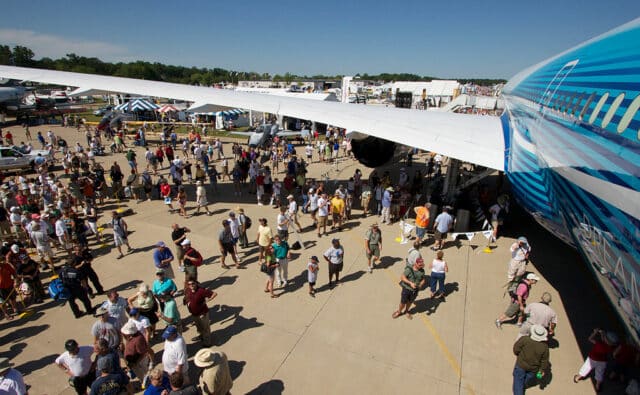
Fatal Crash Overshadows Opening Day of EAA AirVenture Oshkosh 2024
On Monday, the 22nd of July, a Lancair Super ES crashed on approach to Wittman Regional Airport (KOSH) flying into the EAA AirVenture Oshkosh. Oshkosh is the aviation event in the US and during the event, KOSH becomes the world’s busiest control tower. For that one week, Oshkosh has the highest concentration of aircraft in the world.
With that much traffic, sadly, the odds are that something is going to go wrong for someone and the opening of the event started with this fatal crash.
AirVenture has four ATC facilities and every year, the FAA release detailed charts for the flight procedures, specifying who to talk to when and the alternate airports for diversion (Fond du Lac, Appleton and Green Bay), all of which offer ground transportation to the airshow.
VFR aircraft, that is, where the pilot is flying visually rather than by instruments, fly in by following a railroad track from Ripon to Fisk. Fisk Corners is a small neighbourhood in Wisconsin which has outsized notoriety to US pilots who have ever been to Oshkosh, as that is the location of Fisk Approach Control.
Fisk Approach Control is a temporary FAA approach control facility which pops up every year to ensure separation and guide visiting aircraft to Wittmann Field during EAA AirVenture Oshkosh. They offer advice and ensure separation for the aircraft flying into the field. Fisk Control is actually just a small white trailer on top of a hill with FAA air controllers sitting in lawn chairs with a radio and binoculars.
From this year’s FAA notice:
Proceed single file, directly over the railroad tracks from Ripon northeast to Fisk (10 miles). Remain at least mile in-trail behind any aircraft you are following. Do not overtake another aircraft unless authorized by ATC.
Do not “S-turn” to follow an aircraft; instead, break off the procedure; proceed to the starting point; and follow another aircraft of similar speed.
Pilots may reference Ripon and Fisk VFR Waypoints, VPRIP and VPFIS. All aircraft must visually navigate directly over the railroad tracks from Ripon to Fisk.
If possible, lower your landing gear prior to reaching Fisk.
The small town of Pickett is about 4 miles from Fisk (steam from the grain drying facility). After this point, listen very carefully for ATC instructions directed at your aircraft.

All this to say that flying into Oshkosh during AirVenture is a big deal, with a lot of moving parts. Most years, something goes wrong solely on the extreme numbers of fly-in members, which is growing every year.
Sadly this year, an aircraft crashed with two on board on the first day of the event. The crash was two miles (3.2 km) south of Wittman Regional Airport.
The aircraft, a Lancair Super ES registered as N18BG, is a low-wing single-engine aircraft originally sold as an American kit plane. It’s a high-performance aircraft which doesn’t like to fly slow, which may have been the issue. The owner of the aircraft has been flying since at least 2012.
Although the names of the two men in the cockpit have been released, the statement did not include who was flying. They departed Hartford Municipal Airport in Wisconsin at 11:45. The weather was clear with scattered clouds and light winds.
There are not very many details available yet but the ATC recording has been saved on LiveATC (download). I’ve taken the time to transcribe the relevant interactions.
| Fisk Approach Control: | Low wing up high, half mile southwest of Fisk, rock your wings and say type. |
| Lancair N18BG: | Lancair |
| Fisk Approach Control: | All right Lancair. You prefer [runway] 27 or 36? |
| Lancair N18BG: | We’ll take 36. |
| Fisk Approach Control: | Roger, once you get to Fisk here, you can start your right turn. Right turn, follow that east/west road, keep the microwave antenna off to your right side. Start that right turn now and follow that road over to 36, left base 36. Start that right turn. |
| Lancair N18BG: | 36, here we go. |
| Fisk Approach Control: | Lancair, affirmative. It’s 36, left base for runway 36. |
| Lancair N18BG: | Left base 36. |
| Fisk Approach Control: | Lancair, you can monitor Tower 126.6. Welcome to Oshkosh. |
| Lancair N18BG: | Thanks. |
| Oshkosh South Tower: | Low wing, half a mile south of the tower, widen out just a little bit. You’re gonna be following a flight of two, L-39 and an L-29, in the right base. Opposite right base. |
| Lancair N18BG: | In sight. |
| Oshkosh South Tower: | Follow the two aircraft. Runway 36 *left*. Cleared to land at or after the yellow dot. |
| Lancair N18BG: | At or after, wilco. |
| Old Crow: | Understand, that was 36 *right* for Old Crow? |
| Oshkosh South Tower: | Old Crow, yes, 36 right for the overhead. |
| Old Crow: | Wilco. |
It is unclear what went wrong at this point. It’s possible to review a playback of the flight on FlightRadar 24. The final return was at 12:13 local time. The ASD-B data shows the Lancair’s speed decaying to 56 knots before rising again as it descended at 375 feet per minute: consistent with a stall followed by a drop. The Lancair ES brochure gives a stall speed of 65 mph, which is just over 56 knots. However, when it comes to height and speed, ADS-B data accuracy can be questionable, depending on the aircraft’s instruments and especially during rapid changes.
And it was rapid; the Lancair was turning towards the runway at about 1,000 feet when it crashed into a soybean field two miles from the runway. An agricultural scientist told local press that he heard a “pop” and turned around to see the flames. He called the owner of the field who immediately called 911.
At the same time, a second controller at Oshkosh Tower realised that something must be wrong.
| Oshkosh South Tower: | Warbirds rolling out on runway 36L, continue straight. |
| Oshkosh Tower (2nd controller): | B25, do you seen an aircraft down to your left? |
| B25: | Standby… Do not. |
| Oshkosh South Tower: | What are we looking for? |
| Tower 2: | Possibly a downed aircraft off the approach end of 36. |
| B25: | Yeah, we got it. He’s on fire, just off of our left side at the tree line. |
| Tower 2: | Roger, thank you. |
| B25: | Just south of that quarry area. |
| Tower 2: | Thank you. |
| Oshkosh South Tower: | Old Crow, I’m going to have you…I need to turn you out. You’re going to have to be two thousand. Proceed back to Warbird Island. Just use caution for the B25 that’s overflying northbound over the airport. |
| Old Crow: | Back out to Warbird Island and I’ve got the B25 in sight. |
| Oshkosh South Tower: | All right, thank you. |
| Old Crow: | No worries. |
| Old Crow: | Old Crow has the aircraft [unintelligible] in sight. |
| Aircraft: | Air Land on the left base for 36, can we descend? |
| Oshkosh South Tower: | Unable to descend. You’re going to have to hold your altitude and just stand by one. We can’t bring anybody to the airport now. |
| Aircraft: | Standing by. |
| Tower 2: | Anyone inbound to [unintelligible] right now, you are going to need to follow any diversion procedure and find another aircra– airport to land at right now. |
| Old Crow: | Do I need to divert? |
| Tower 2: | Old Crow, yeah, I would divert if you want to go to Fond du Lac it’s probably your best bet. I’m…it’s going to be a little while. |
| Old Crow: | Yeah, could you give me the tower frequency? It wasn’t in the notice. |
| Tower 2: | Fond du Lac Tower is 120.4 |
| Old Crow: | 120.4 thank you. See you in a bit! |
| Tower 2: | Sorry. |
| Old Crow: | Ah, it happens. |
| B25: | Tower, B25 is cleared to the north. |
| Oshkosh South Tower: | B25, thanks. |
Meanwhile, Chris Reed, a private pilot who was attending the event, saw the plume of smoke in the distance and realised that an aircraft must have crashed at the south end of runway 36.
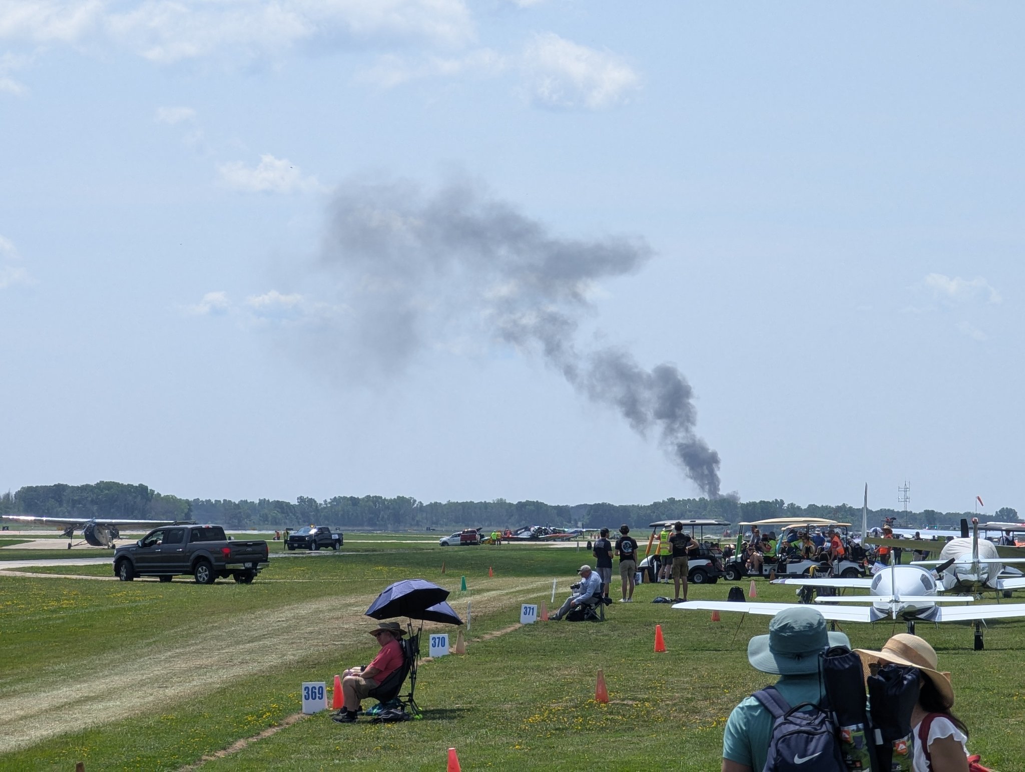
Air Traffic Control reported the crash at 12:15. Emergency services were rapidly on the scene, including the Oshkosh Fire Department, the Nekimi Fire Department and the Winnebago County Sheriff’s Department. They arrived to find the aircraft burning furiously, with no chance of survival.
I cannot read the media release about the victims from the Winnebago County Sheriff’s Office as they have blocked all of Europe but this has been quoted in multiple different news media:
Official medical examiner confirmation will take additional time, however, after the initial investigation, there is no reason to believe the occupants were anyone other than Mr. Tommervik and Mr. Sullivan,” the sheriff’s office statement said.
That sure tells us something about the state of the wreckage.
The NTSB were on the scene and have confirmed that the investigation is in progress.
Two lives lost on the opening day of AirVenture 2024 is tragic. However, we should not rush to condemn the airshow but continue to work as a community to avoid the risks involved in high-traffic environments, which is a problem around the world. I know that EEA AirVenture has already made changes based on the two crashes last year. The NTSB’s investigation will likely provide valuable insights to help prevent similar incidents in the future, ensuring that AirVenture and other major aviation events can continue to take place while prioritizing the safety of everyone involved.


Such a sad way to start the event :(
I will be very interested in reading the full discussion of this crash (to the extent that anything can be figured out from a wreck that probably didn’t have any sort of flight data recorder). From what I see on Google Maps, 36R is a taxiway renamed for the event (the “satellite” view shows the mixed markings); even so, the L-39 and L-29 (if they’re what Wikipedia shows under those IDs) are small enough (jet trainers) that I’d have thought they would be directed to take the right base to 36R instead of crossing over it to 36L. That probably wouldn’t have made a difference, but they were one more thing to divert the Lancair pilot’s attention from keeping his plane in the air.